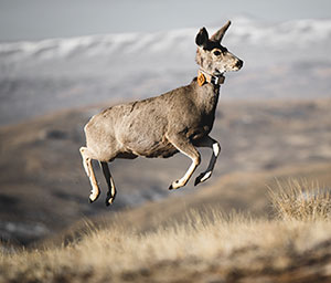
A mule deer is released wearing a GPS collar. The data from this collar will enable
researchers and managers to track the migrations of mule deer and evaluate their habitat
use and population performance to aid in management of mule deer populations in Wyoming.
(Ben Kraushaar Photo)
For the first time, researchers have published a geonarrative revealing the record-breaking
journey of Deer 255, whose story illustrates the challenges and opportunities for
conserving migratory mule deer herds across the changing American West.
Users can scroll through the online narrative to peruse maps, videos and recent findings on the migration dynamics of Rocky Mountain
mule deer. The project draws on collaborative research by the U.S. Geological Survey’s
(USGS) Wyoming Cooperative Fish and Wildlife Research Unit at the University of Wyoming,
the Wyoming Game and Fish Department and many other partners.
Among the thousands of deer migrations tracked thus far across Western states, the
researchers found that Deer 255 makes the longest point-to-point mule deer migration
on record.
Her 480-mile round-trip journey stretches from the greater Yellowstone ecosystem to
southern Wyoming’s Red Desert. That’s the longest documented land migration in the
lower 48 states and second only to caribou in North America.
The geonarrative follows Deer 255’s fall migration route from end to end, taking the
reader through each leg of the trip and the obstacles the adult doe faces during migration.
The story of Deer 255’s journey paints a picture of the modern West -- diverse habitats
managed by many hands, rapidly changing in the face of a growing human footprint and
climate change. By tracking mule deer like 255 and her herd, researchers learn not
only where they go and how long it takes, but also how changes on the land can influence
migratory behaviors.
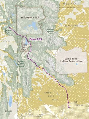
The route of Deer 255 passes through lands managed by a diversity of agencies and
owners, from national parks and national forests (green) to Bureau of Land Management
land (yellow) and private land (white). (Cartography by InfoGraphics Lab, Department
of Geography, University of Oregon; and Emily Reed, Wyoming Migration Initiative at
UW)
Deer 255 and the rest of the herd follow an annual cycle tied to spring green-up of
plants so that they are always eating the most nutrient- and protein-dense greens,
a phenomenon known as “surfing the green wave.”
“Deer strongly choreograph their movements to match the green-up, which means they
are migrating for a couple of months, not just a couple of days,” says Matt Kauffman,
director of the Wyoming Cooperative Fish and Wildlife Research Unit and the Wyoming
Migration Initiative at UW. “These deer rely not only on habitat in their summer and
winter ranges, but also along their migration routes.”
Kauffman and his team fitted Deer 255 with a GPS collar in the Red Desert in spring
2016.
Her GPS collar malfunctioned on her Island Park, Idaho, summer range before she migrated
back to the Red Desert, leaving researchers to wonder whether the long trip was a
fluke. But, in 2018, Deer 255 was found and captured again and fitted with a new GPS
collar. In the years since, she has repeated the 242-mile journey and shorter variations.
Traveling hundreds of miles from the mountains to the desert, Deer 255 and her herd
pass through a patchwork of land composed of national parks, working ranchlands and
developed areas. The barriers the deer cross are both physical and jurisdictional,
ancient and brand-new, from the craggy mountain ranges of the Tetons and long, narrow
glacial lakes to the fences and highways that cut Wyoming’s lands into private and
public parcels.
Protecting a population that migrates long distances is a challenge that won’t fit
within the bounds of a single protected area such as a national park. Mapping these
migrations can inform management decisions, including planning for housing and energy
development or helping attract funding for public-private partnerships.
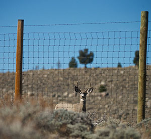
Mule deer taking Deer 255’s route must cross nearly 200 fences annually on their seasonal
migrations. (Joe Riis Photo)
For example, the researchers tracking Deer 255’s herd identified a critical bottleneck
in the migration corridor that crossed a parcel of land slated for a new housing development.
This sparked a $2.1 million conservation effort to protect the bottleneck and ensure
safe passage of migrating deer.
Mule deer that migrate shorter distances can provide plenty of useful information,
too. Following 14 years of tracking a population in south-central Wyoming, the researchers
were able to see that these deer slowed down when they encountered natural gas projects,
throwing off their ability to “surf the green wave.”
Deer 255’s story map illustrates all of these topics, showing how data provides tools
to maintain functionality of migration corridors for future generations. The geonarrative
was developed to be embedded in the American Conservation and Stewardship Atlas that the USGS is creating for President Biden’s America the Beautiful initiative.
“We’re excited that this work will be featured in the Conservation Atlas,” Kauffman
says. “The immersive map products we are creating make scientific research accessible,
helping provide context to the local communities that interact with these migrations,
such as ranching operations.”