Watershed Hydrology on Libby Creek
Merging Research and Education Through Field Study
Snowy Range, Wyoming
Summary: Wildland hydrology is a field-based discipline that is highly reliant on a variety of instruments that collect meteorological, hydrological and soil state data. In REWM4285 (Wildland Hydrology), students apply advanced techniques for management, manipulation, modeling and interpretation of these data. In the past, the course has been taught in a traditional class-based manner with little or no exposure to field equipment, data collection, or processing. While this approach is fundamentally sound, is creates a critical gap in knowledge and understanding: that of the transformation from raw to useful data. In addition to this gap, I have observed that virtually none of the incoming graduate students or undergraduate students have any knowledge of or contact with field instruments, which is a concern since they are at a competitive disadvantage for job applications requiring field work and (of more concern to academic pursuit) may fail to understand the host of attendant data management and interpretation issues that are related to field data collection, including sources of error and uncertainty. Over the past two years the class has been re-engineered to build upon a field campaign in which students are exposed to standard and cutting-edge data collection efforts and given hands-on exercises in which they explore and better understand data and its limitations. Furthermore, field data collection occurs year-round and is providing a rich data source for a variety of research scientists who are collaborating on the project. The goal of this effort is to fully link education and research for the advancement of hydrologic understanding in the Rocky Mountains.
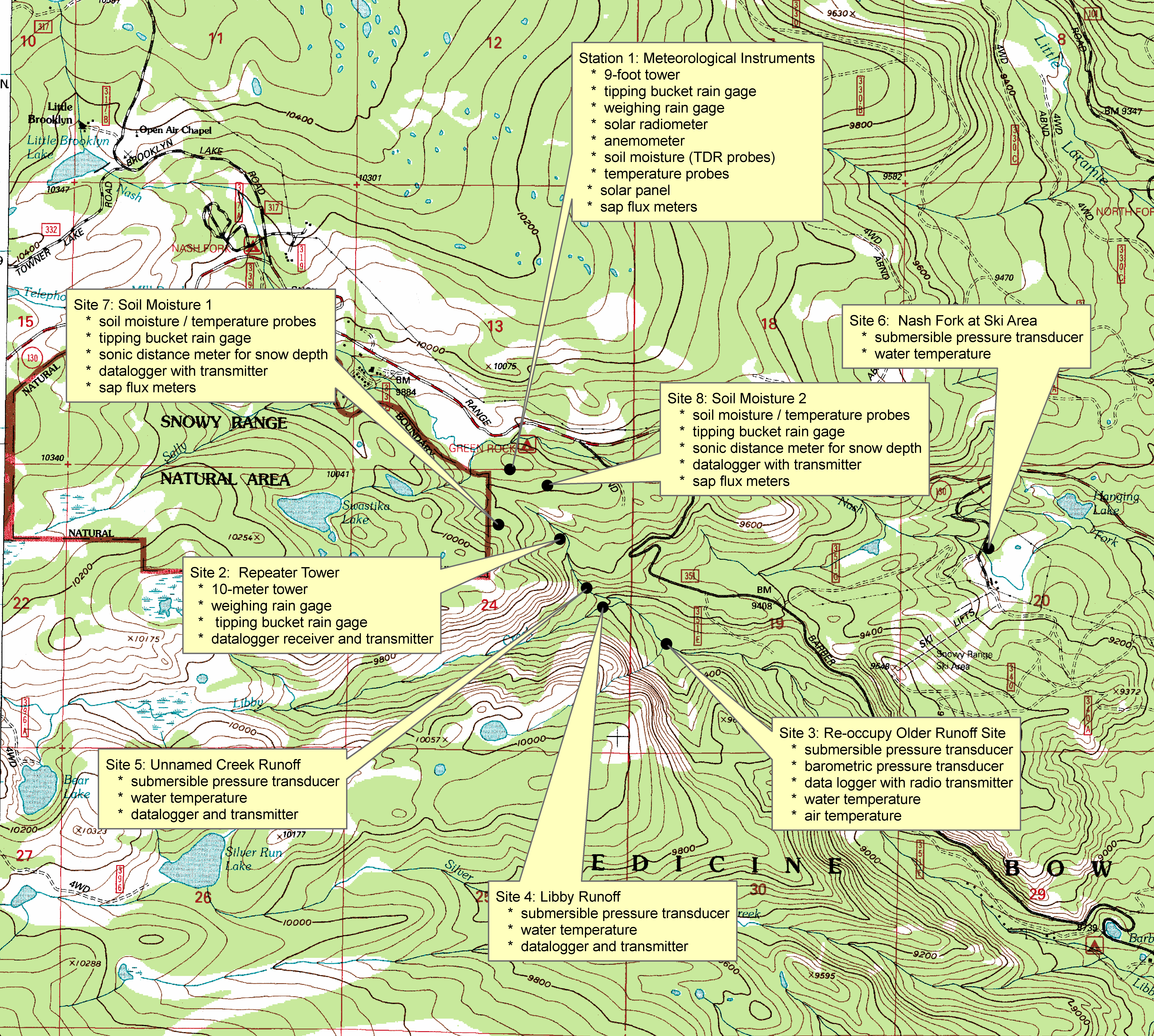
Project description. We have installed a network of gages and sensors at sites within the Libby Creek watershed with intensive instrumentation in an unnamed 1st-order watershed that will allow us to fully describe the hydrological system. The emphasis of the research is hydrological, with the installation of four (4) continuous runoff gages within the streams of Libby Creek, the unnamed contributing watershed, and one on Nash Fork near the ski area. However, we have also installed 3 suites of soil moisture sensors, a meteorological tower for collecting weather data, two (2) sets of rain gages (3 gages total), automated water samplers, sap flux meters and associated radio telemetry. All access is via established paved roads and maintained service roads (to the ski area and sites near or adjacent to Green Rock Campground and the Barber lake Road) and then on foot / skis / snowshoes to get to the other sites. Equipment is left in the field year-round with weekly access to visit the sites and establish function / failures. Data are sent via radio communications to the central meteorological site and then forwarded to campus via cell network.
Figure 1 - Locations of the field instrumentation near Laramie (click to enlarge)
Table 1. Locations of sites and equipment to be placed in the Study Area
|
Site Identification |
Longitude (dd) |
Latitude (dms) |
Equipment list |
|
Site 1: Met Station
|
106 12� 59.1� W |
41 20� 48.6� N |
9-foot tower Weighing type rainfall gauge Air temperature Wind speed Incoming solar radiometer Soil moisture (TDR) probes Soil temperature Sap flux meters Tipping bucket type rainfall gauge Solar panel Datalogger receiver and transmitter |
|
Site 2: Repeater |
106 12� 46.65� W |
41 20� 35.97� N |
Radio repeater on 10-meter tower Weighing rain gage Tipping bucket rain gage Datalogger receiver and transmitter |
|
Site 3: Reoccupy older runoff station
|
106 12� 20.38� W |
41 20� 17.02� N |
Submersible pressure transducer Water temperature Pump sampler Pressure transducer for barometric pressure Air temperature |
|
Site 4: Libby Runoff |
106 12� 36.02� W |
41 20� 23.57� N |
Submersible pressure transducer Water temperature |
|
Site 5: Unnamed Creek Runoff |
106 12� 40.01� W |
41 20� 27.07� N |
Submersible pressure transducer Water temperature Datalogger and transmitter |
|
Site 6: Nash At Ski Area
|
106 11� 2.36� W |
41 20� 35.34� N |
Submersible pressure transducer Water temperature Weighing-type rainfall gauge |
|
Site 7: Soil Moisture 1
|
106 13� 1.67� W |
41 20� 38.45� N |
Soil moisture / temperature probes Temperature probes Tipping bucket rain gage Sonic distance meter for snow depth Sap flux meters |
|
Site 8: Soil Moisture 2
|
106 12� 49.92� W |
41 20� 45.75� N |
Soil moisture / temperature probes Sonic distance sensor for snow depth Sap flux meters |