The U.S. Geological Survey (USGS), in partnership with the University of Wyoming and many other collaborators, has published the third volume in a series of new maps of big-game migration corridors.
The new maps add more valuable tools for land managers and policymakers to mitigate the impacts of development on wildlife.
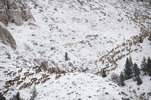
Each spring and fall, deer, elk, pronghorn and other hoofed mammals migrate throughout the western United States, a critical behavior that allows them to avoid deep snow and access the most nutritious forage. But, as the human footprint in the West expands, these migratory animals increasingly face obstacles such as new development, impermeable fences and high-traffic roads.
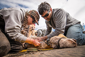
Detailed mapping from GPS collar data, such as those in this map series, can help identify where migrations overlap with existing and potential barriers to movement. A state-tribal-federal partnership, known as the Corridor Mapping Team, has been working to develop standard techniques to map migration corridors and make migration maps available to the public.
Since its inception in 2018, the Corridor Mapping Team has expanded to include participation from all 11 state wildlife-management agencies in the West as well as from multiple tribal and federal agencies.
“Many ungulate herds must migrate to thrive on the strongly seasonal landscapes of the American West. These corridor maps make it possible to plan for keeping those corridors open,” says the report’s lead author, Matt Kauffman, a research wildlife biologist with the USGS Wyoming Cooperative Fish and Wildlife Research Unit, which has been a regional hub for migration studies at UW.
The first two sets of maps published by the team were released in 2020 and early 2022. This week’s release includes maps and summaries of 45 mule deer, white-tailed deer, pronghorn and elk migration routes in Arizona, California, Idaho, New Mexico, Utah, Washington, Wyoming and, for the first time, the Navajo Nation.
With this latest volume, the series includes details and maps of the migrations and seasonal ranges for a total of 152 herds, along with insights into how earlier migration maps are being used in conservation planning.

“When the first sets of maps came out, we were excited about how these maps could be used for conservation planning, but that was mostly aspirational,” Kauffman says. “Now, in Volume 3, we have examples of how migration maps are being used on the ground.”
For example, state and tribal wildlife agencies, in partnership with transportation agencies, have used the migration maps to plan and construct wildlife underpasses and overpasses that allow animals to safely cross major highways or to develop message boards and automatic systems along highways to alert drivers of crossing animals. Maps also are being used to remove fences, inform recreation planning, guide siting of renewable energy projects and limit housing development in migration corridors through zoning and conservation easements.
The broader corridor-mapping effort illustrates how collaborations among state, federal and tribal agencies and private landowners can help wildlife coexist with human populations even as Western landscapes undergo major changes.
Other report co-authors on the latest volume include managers from wildlife agencies in Arizona, California, Colorado, Idaho, Montana, Nevada, New Mexico, Washington and Wyoming; the Navajo Nation Department of Fish and Wildlife; the Nevada Department of Transportation; the Southern Ute Indian Tribe; the University of Oregon; Southern Illinois University; The Nature Conservancy; the Mule Deer Foundation; the Teton Conservation District; Teton Science Schools; and Western EcoSystems Technology Inc. Maps of each herd were produced in collaboration with regional experts by cartographers from the USGS and the InfoGraphics Lab at the University of Oregon.
The report, “Ungulate Migrations of the Western United States: Volume 3,” can be accessed at: https://pubs.er.usgs.gov/publication/sir20225088.
To explore migration routes and ranges, visit the interactive www.westernmigrations.net portal, or download the data from www.sciencebase.gov.

