
The Wyoming Geographic Information Science Center (WyGISC) at the University of Wyoming has launched the Wyoming LiDAR (light detection and ranging) Data Portal, providing unprecedented public access to high-resolution elevation and contour data across the state.
The portal was unveiled last week at the Wyoming Geospatial Organization spring 2025 conference in Casper by WyGISC, a unit of UW’s School of Computing.
Available at https://lidar.wygisc.org/, the portal is a free, public resource designed to make advanced geospatial data easily accessible to communities, agencies, researchers and everyday users across Wyoming.
“This is a major step forward in public access to high-resolution elevation data for the state of Wyoming,” says Shawn Lanning, a geospatial specialist with WyGISC, who helped develop the portal alongside project leader Jeff Hamerlinck and colleague Shannon Albeke. “With just a few clicks, users can now explore and download elevation and contour data for any area of the state.”
The Wyoming LiDAR Data Portal offers:
-- Statewide digital terrain models and 2-foot contour data created using high-resolution LiDAR data.
-- Centralized access to Wyoming-specific LiDAR datasets and derivative products.
-- Tools for data visualization, download and exploration, all through an intuitive interface.
This effort was made possible through a one-time legislative appropriation of $2 million in 2023, which funded the development of 2-foot contours, supporting digital terrain models and the portal itself. WyGISC led the project in collaboration with Woolpert, a geospatial engineering firm.
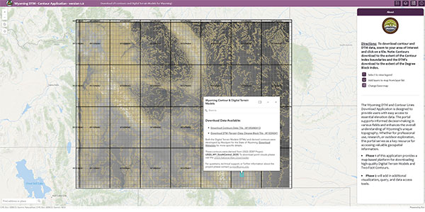
This image shows a Wyoming LiDAR Data Portal contour and digital terrain model download application in use. (UW Photo)The portal is intended for anyone in Wyoming who needs reliable elevation and topographic data, including:
-- Landowners and planners evaluating development or agricultural projects.
-- Researchers and students conducting environmental or geological studies.
-- Emergency management teams preparing for or responding to natural disasters.
-- Outdoor enthusiasts and drone operators needing terrain-aware tools.
-- Local and state agencies supporting infrastructure and natural resource planning.
Phase 2 of the project is already in development and will involve further collaboration with stakeholders statewide to expand available datasets and improve user tools.
For more information, email wygisc@uwyo.edu.
The University of Wyoming has earned its Research Level 1 (R1) status from the Carnegie Classification of Institutions of Higher Education, placing Wyoming's only four-year university with the top research universities in the United States.