
UW 3D Visualization Center Conducts Comprehensive Remote Sensing Field Work Amid Technology Upgrades
Published July 29, 2025
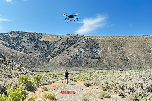
Kyle Summerfield, program manager of the 3D Visualization Center, or Viz Center, within the University of Wyoming’s School of Energy Resources, operates the HySpex Mjolnir VS-620 mounted on a heavy-lift drone in southwest Wyoming. The technical piece of equipment will support critical mineral mapping and geological characterization across a variety of terrains. (James Amato Photo)
The 3D Visualization Center (Viz Center) in the University of Wyoming’s School of Energy Resources (SER) is known to house state-of-the-art technology to enhance visual learning and innovative research.
Formerly home to the only four-walled 3D CAVE in Wyoming, the Viz Center has revolutionized its capabilities and upgraded its technology suite to significantly enhance energy-driven research within SER, the wider university, and the energy and mining industries in Wyoming.
Specifically, the Viz Center has made a major investment in its remote sensing program with the addition of a drone-based VNIR-SWIR hyperspectral imaging (HSI) system offering centimeter-scale resolution. The overarching goal is to build in-house capacity for both academic research and applied geospatial data collection.
“Hyperspectral imaging is a relatively new generation of remote sensing that acquires and analyzes reflected light in different regions of the electromagnetic spectrum,” says James Amato, an associate research professional and division manager in the Viz Center. “With significantly higher spectral resolution than traditional multispectral systems, this technology allows for precise identification and characterization of surface materials and substances.”
This ability will be crucial for the exploration and identification of critical minerals in the state -- including in coal and waste streams -- a major priority of SER’s research.
“Implemented primarily for mineral exploration, the newly acquired HySpex Mjolnir VS-620 will support critical mineral mapping and geological characterization across a variety of terrains,” Amato says. “Every mineral has a unique spectral thumbprint; hyperspectral imaging can be used to detect the distinct spectral response on how each mineral reflects and absorbs light at specific wavelengths. This allows for accurate identification and mapping of mineral compositions, even in complex or visually uniform geological settings.”
With such potential to make a significant impact on an emerging industry, the research team members in the Viz Center have been spending the summer months honing their skills and perfecting their craft in preparation for their expertise and resources to be used throughout the region.
The team is undertaking nearly six weeks of intermittent field operations in southern Wyoming. This period is dedicated to mastering the nuances of data capture and post-processing raw data into corrected, usable hyperspectral datasets.
“These training sessions are meant to help us determine issues that can arise from atmospheric conditions, as well as help us navigate the workflow of analysis and image classification,” says Kyle Summerfield, program manager of the Viz Center. “With any new equipment, there are always unanticipated challenges that we want to be prepared to address. The team has been outstanding throughout this endeavor, and we are really looking forward to implementing our new learnings.”
The planned deployment of the new aerial and field-based services is scheduled to commence in 2026. However, with the versatility of the sensor, lab work is intended to begin in the fall and winter months for high-resolution scanning of drill core and hand samples. These capabilities will become a major staple in SER’s current critical mineral projects within the Center for Economic Geology Research, as well as be an important feature in future grant proposals.
To further enhance research, the team hopes to forge stronger collaborations with the Colorado School of Mines, another institution boasting similar advanced facilities, the Wyoming State Geological Survey and the United States Geological Survey, whose comprehensive spectral library of minerals will be used for classifying datasets.
“The Viz Center’s recent strategic investments and infrastructure upgrades have established it as the sole facility in Wyoming with such advanced capabilities,” Summerfield adds. “These capabilities provide a robust platform for innovative research and strategically position the Center to offer commercial geospatial data services in the foreseeable future.”
The University of Wyoming has earned its Research Level 1 (R1) status from the Carnegie Classification of Institutions of Higher Education, placing Wyoming's only four-year university with the top research universities in the United States.