
New Maps Reveal Extensive Pronghorn Migrations Across Northern Sagebrush Steppe
Published November 20, 2025
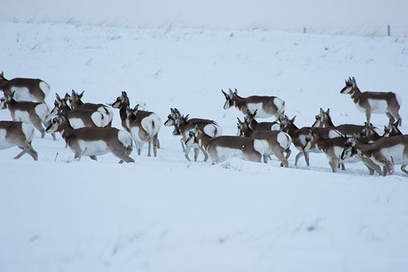
Pronghorn move in one of the migration routes that bisects the Northern Sagebrush Steppe in Montana and Canada. (Paul Jones/Alberta Conservation Association Photo)
In 2004, a female pronghorn made the longest-recorded migration for her species, traveling
from Manyberries, Alberta, Canada, north to her summer range into Saskatchewan and
back for a total distance of 552 miles. She crossed major highways, numerous fences
and provincial boundaries on her trek.
This individual’s journey and many others were captured in new migration maps released
this week documenting two extensive pronghorn migrations in the Northern Sagebrush
Steppe, spanning southern Alberta and Saskatchewan, Canada, and northern Montana.
The maps were published in the Atlas of Ungulate Migration, a growing compendium of migration maps depicting ungulate (hooved mammal) populations
around the world.
This work is led by the Global Initiative on Ungulate Migration (GIUM), a partnership
of international researchers headquartered at the University of Wyoming that is producing
detailed maps to guide conservation and infrastructure planning to conserve threatened
migrations worldwide.
The first new map depicts pronghorn wintering in Alberta and then traveling to summer
ranges farther north, while the other map shows animals living in the transboundary
region of Saskatchewan and Montana and migrating between the two jurisdictions. Tracking
data indicate that some individuals move between these two migratory systems.
The new maps reveal both the impressive extent of the animals’ seasonal journeys as
well as the intensity of barriers they face on this changing landscape.
Tracking data for the migratory movements occurring in Alberta were provided by Alberta
Conservation Association (ACA), which leads ongoing efforts to monitor and conserve
pronghorn and their habitats. Paul Jones, a wildlife biologist with ACA, was a key
contributor to the maps and author of the associated fact sheets describing the movements
and the challenges pronghorn face.
“Because pronghorn here live at the northern periphery of the species’ range, they
have to be able to migrate sometimes incredibly long distances to escape deep snow
and harsh conditions,” Jones says. “Maintaining a truly connected landscape for migratory
pronghorn is essential to ensuring their populations can thrive.”
Aside from the distance, the migrations depicted in the maps are a true feat considering
how many pronghorn can die attempting to escape winter conditions. Many pronghorn
die because they are unable to crawl under poorly designed fences, and they are increasingly
hit by cars and trains on the major east-west routes.
One of the routes is the Trans-Canada Highway, a major transportation corridor that
bisects the Northern Sagebrush Steppe and impedes pronghorn movements. The Trans Canada,
which is fenced in many sections and is paralleled by a railroad, is a significant
barrier for pronghorn migration.
“There are currently no crossing structures for wildlife on the Trans Canada,” Jones
says. “But using tracking and collision data, the Miistakis Institute, in partnership
with ACA and the Canadian Wildlife Federation, have identified several places where
we can now recommend building over or underpasses.”
Part of the extensive and connected Northern Sagebrush Steppe metapopulation, pronghorn
migrating in southern Saskatchewan and into Montana face similar challenges.
Andrew Jakes, a senior researcher with the Wyoming Migration Initiative and key data
contributor and author for the maps, says that, among the many challenges that linear
features such as fences and roads pose, one of the major unresolved issues for migratory
pronghorn in the Northern Sagebrush Steppe is train collisions.
“Pronghorn are built to outrun predators, but they can’t outrun trains,” Jakes says.
“In my time studying pronghorn, I’ve witnessed several mass winter mortality events
when large groups congregate on railways but are unable to maneuver off and are struck
from oncoming trains.”
In winter 2011, several hundred pronghorn in Montana were killed by trains in a series
of collision events. Attracted to the rail line because it was free of snow, they
didn’t have an easy way to get off the tracks to escape the train. The collisions
were widely reported in regional media and captured the public’s attention, but little
has been done to prevent ongoing train strikes. In 2020, a similar mass mortality
event occurred on a railroad in Saskatchewan.
“We need to find a way to work with railroad companies to mitigate this issue, through
speed regulations or retrofitting, and identify where these common collision sites
are,” Jakes says.
Today, Jones and Jakes are leading new tracking projects to assess pronghorn migrations
across the Northern Sagebrush Steppe, including identification from traditional ecological
knowledge, to gain a more comprehensive picture of what factors are constraining the
animals’ movements and survival. These tracking studies aim to shed light on where
to best direct conservation efforts.
“This landscape is unique in that pronghorn are crossing international and provincial
boundaries, and it will take a lot of work and communication with landowners and continued
planning to make sure it remains permeable for them,” Jakes says. “We believe these
maps can be powerful tools in the effort to conserve pronghorn migrations and identify
mitigation opportunities so that they can move freely and access important seasonal
ranges.”
The atlas provides detailed maps, fact sheets and spatial data so that stakeholders
in the region can incorporate the information into ongoing conservation planning.
This approach -- using detailed maps to guide habitat restoration efforts -- has proven
to be an effective means to advance conservation of ungulate migrations around the
world.
Migration maps and related resources are available through the Atlas of Ungulate Migration, which is implemented under the auspices of the Convention on the Conservation of Migratory Species of Wild Animals, a United Nations treaty. View the atlas at www.cms.int/gium.
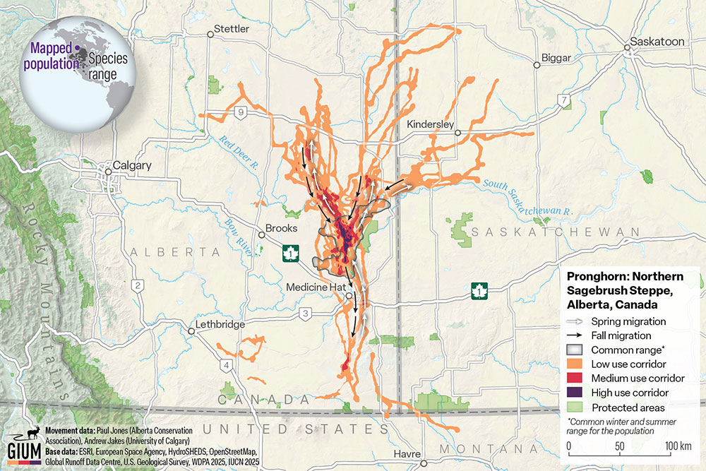
This is one of the new maps published in the Atlas of Ungulate Migration, a growing compendium of migration maps led by the Global Initiative on Ungulate Migration, a partnership of international researchers headquartered at the University of Wyoming.
The University of Wyoming has earned its Research Level 1 (R1) status from the Carnegie Classification of Institutions of Higher Education, placing Wyoming's only four-year university with the top research universities in the United States.