
An Integrated Approach to Aquatic Ecosystem Science in Wyoming’s Headwaters
Kevin Gauthier and Chuck Williams
Published March 07, 2025
This two-part blog post is adapted from a presentation held in December 2024. Presenters and authors: Kevin Gauthier and Chuck Williams.
Kevin Gauthier: “I'm a research technician for WyACT’s Aquatics team and joined the project about two years ago. Our team collects data on lakes and rivers in northwest Wyoming to establish a baseline understanding of water quality and ecology in these data-poor ecosystems. We plan to use the data to inform models of both present and future conditions within these lakes and rivers. In order to learn anything about long term trends, we need to start clocking data now!
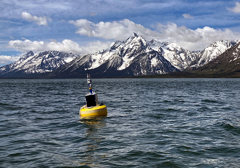
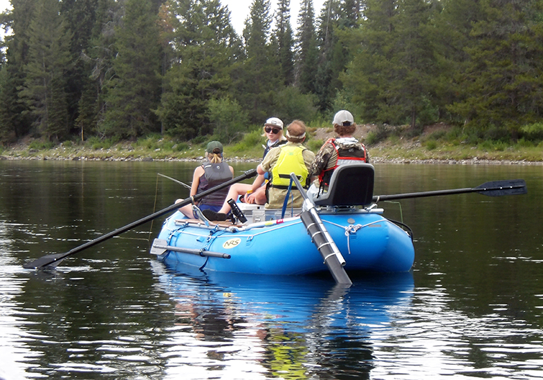
We focus on three lakes: Jackson Lake, Boysen Reservoir and Brooks Lake. We use three methods of data collection: buoys, a system called FLAMe, and more traditional, manual lake monitoring efforts. These approaches can complement one another as we are thinking about these lake ecosystems as a whole.
Buoys only capture one fixed point
Monitoring buoys are stationed at a single point on each lake. They record data every 10 minutes, resulting in a high-resolution time series of variables like temperature and algae growth. Temperature and the biomass of algae impact habitat, recreation and water quality in these three lakes. Once deployed, the buoys work independently all summer. They transmit information remotely, so we can use them to display water quality data to managers and community members in real time. We have observed algae blooms in real time on Boysen Reservoir and Brooks Lake, whereas Jackson Lake has shown minimal algae growth.
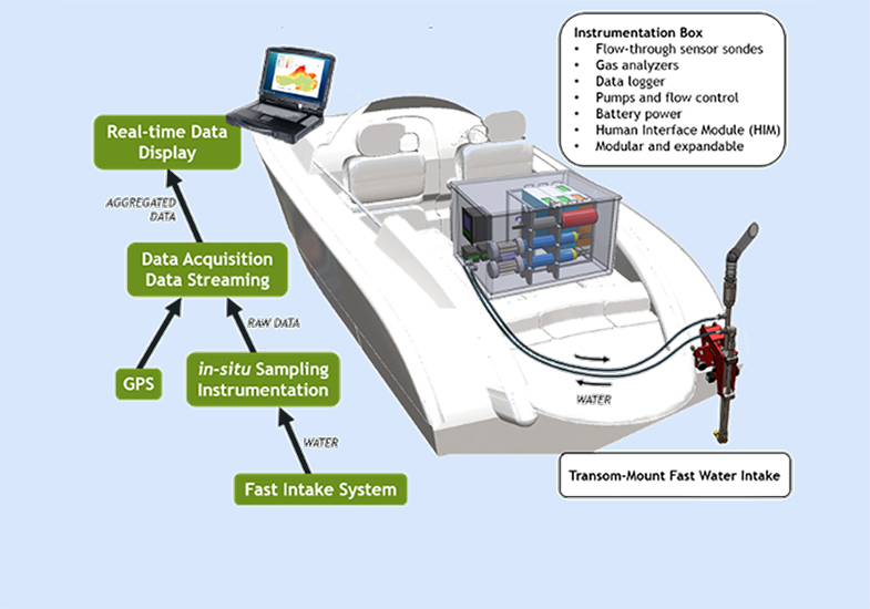
The buoys are fixed at one point, limiting their ability to assess the physical habitat and water quality across the entire surface of the lakes. Our research team is interested in what the buoy measurements may be missing, particularly across large water bodies like Jackson Lake and Boysen Reservoir. To address this knowledge gap, we use an instrument called the FLAMe (Fast Limnological Automated Measurements) mounted on a boat. It pumps water from the lake through tubes and various sensors as you drive across the lake. Data are recorded every second as you drive and are linked to a GPS, resulting in a map of surface water chemistry across the whole lake.
Getting a more complete picture
Measurements collected by the FLAMe system give us an idea of how well our buoys stationed on Jackson Lake and Boysen Reservoir represent conditions across the whole water body. We see that on any given day, temperature varies across the surface of the lake. In June, for example, Moran Bay in Jackson Lake was colder than the warmest areas close to the dam or the Snake River inlet. In August, however, the lake was coldest near the Snake River inlet and generally warmed as we moved closer to the dam. In June we observed almost a six-degree variation in temperature across the lake surface, and in August almost a three-degree variation, suggesting that localized factors like river inlets (Snake River, Moran Creek, etc.) must be driving spatial differences across the lake surface.
In Boysen Reservoir, we observed changes in both temperature and algae growth across the surface. One day in June, for example, we saw a five-degree temperature variation across the surface of the lake and very patchy algae growth: minimal in the northern half, but considerable in the southern end near the Wind River inlet. As we sampled again in August and October, we saw algae growth shift to different bays of the reservoir. If we relied only on data from a single location, our understanding of how water quality changes throughout the year would be incomplete.
Both seasonality and spatial variation are important in understanding water quality in these lake and reservoir ecosystems. By using buoys to capture seasonal trends and the FLAMe system to capture the whole water body surface, we create a more complete picture of what's actually going on in these ecosystems.
Below the surface
A final dimension of lake water quality and ecology that our research team hopes to understand involves considering the whole water column rather than just the surface. That's where we loop in some of our traditional lake monitoring approaches that include sampling at different depths. Temperature varies with depth, as anyone who has dove under the surface while swimming in a lake to feel the rapid temperature change could tell you, as does the growth of algae. In Jackson Lake, we find the highest density of algae anywhere from 5 to 13 meters (16 to 42 feet) deep. While we are sampling with the FLAMe system at the surface, we are missing the algae growing down deeper, and our limnological monitoring helps capture that.
We have integrated various data collection approaches on lakes and reservoirs in northwest Wyoming to establish a baseline understanding of the water quality and ecology of these regionally important water bodies. As we continue to expand our data collection efforts, we hope to better understand how these ecosystems may change in the future."
Chuck Williams: "I'm a graduate student with WyACT and have been here a little under a year. I’m interested in how temperature and flow can affect habitats within the Snake River and how that might have implications for fisheries and recreation in the Jackson, Wyoming area.
Temperature and flow are important for both fisheries and aquatic ecosystems and subsequently for the associated recreational opportunities they present. With less flow, we might lose habitat for cutthroat trout and other aquatic species Higher flows may result in improved access to suitable habitat and food resources for fish, leading to improved fisheries. High flows can also cause dangerous situations for recreational floaters in extreme cases. Fish have thermal tolerances. If those are exceeded, it can affect their metabolism and their feeding behavior. It could reduce their catchability, limiting angler success. Higher temperatures also open up the doors for warm water specialist species to invade additional habitats and compete with native species in these areas. The Snake River and its tributaries currently offer suitable thermal habitat to sustain a cutthroat trout fishery. Our research group is interested in understanding what impact future change scenarios may have on thermal habitat and flow in the Snake River basin.
Localized seasonal variations and dam releases interact with geographically distinct landscape characteristics such as geomorphology and tributary inputs to generate unique spatial and temporal patterns in mainstem river temperatures and flow. Temperature and flow monitoring of the tributaries will give us important baseline data. We can track change over time and allow managers to make informed decisions for the Upper Snake watershed.
Different types of data collection
Using our future scenarios, climate projections and management, we can model temperature and flow data to try to predict what will happen to fisheries and aquatic ecosystems on the Snake River and to recreational opportunities. To do this, we have set up several ways to collect data.
- Our stream temperature network currently has 30 temperature loggers spread throughout the Upper Snake River basin on both groundwater and snowmelt runoff streams. They have been in place since 2018, giving us six years of data. We used them to create a stream temperature model of the tributaries, as well as for some juvenile cutthroat trout growth rate work. We hope to add more temperature loggers to the mainstem Snake River to increase our understanding of mainstem temperatures.
- We are collecting flow measurements at four tributary sites: two groundwater sites and two snowmelt runoff streams.
- We are installing game cameras to collect timelapse photos of these sites. They are used to create a continuous measurement of relative discharge and collect qualitative information on how each site may be changing. This flow data will be important for our temperature and flow models in the future.
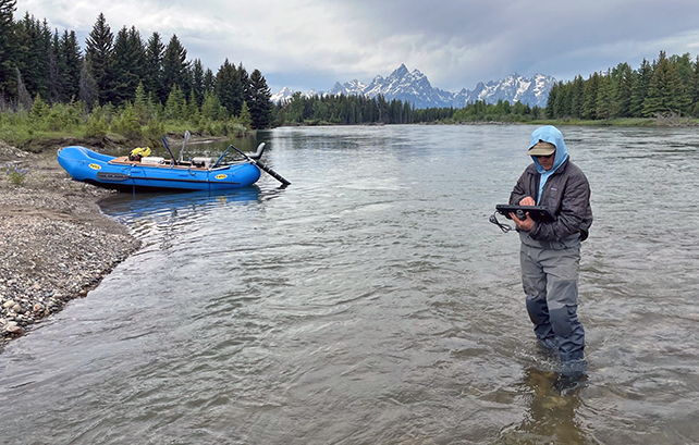
- We are also using the FLAMe (Fast Limnological Automated Measurements) system on the river. We are monitoring a 25-mile stretch of Snake River from Jackson Lake dam to Moose Landing, focusing our temperature monitoring on tributaries and groundwater inputs.
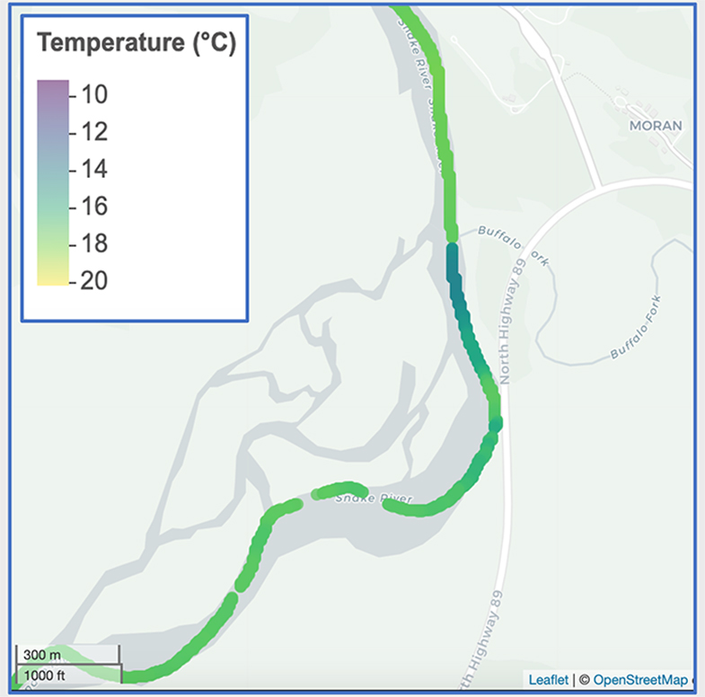 If we zoom in on the Buffalo Fork in July, we can clearly see its influence on the
main stem of the Snake River. The temperature above the Buffalo Fork is around 17.5°C,
and it drops down to about 14°C below the confluence. The river dilutes back to around
the same temperature, although it is still slightly colder than above the tributary
influence. The influence of the Buffalo Fork travels several hundred meters downstream.
If we zoom in on the Buffalo Fork in July, we can clearly see its influence on the
main stem of the Snake River. The temperature above the Buffalo Fork is around 17.5°C,
and it drops down to about 14°C below the confluence. The river dilutes back to around
the same temperature, although it is still slightly colder than above the tributary
influence. The influence of the Buffalo Fork travels several hundred meters downstream.
Data we have collected thus far have allowed us to observe spatial and temporal thermal patterns along the Snake River and may help identify potential hot spots in biological activity. We can also quantify the influence that the tributaries have on creating unique habitat patches along the river. Already after the first season, these data have given us a good baseline to start to ask some more difficult questions. We have also been able to connect with the local groups in Jackson Hole like Protect our Waters, Town of Jackson, Wyoming Game and Fish Department, and Trout Unlimited."
The University of Wyoming has earned its Research Level 1 (R1) status from the Carnegie Classification of Institutions of Higher Education, placing Wyoming's only four-year university with the top research universities in the United States.