
Learning from the past: How prehistoric lake levels can help improve climate models
Published December 02, 2024
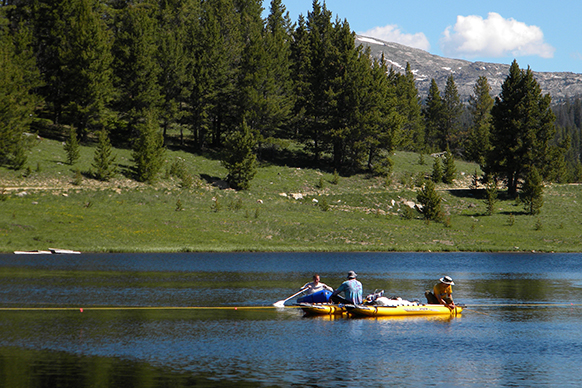
Coring Lower Paintrock Lake (photo courtesy Bryan Shuman)
Imagine Wyoming 12,000 years ago: The ice age is over, and it’s warming up for the Holocene. Prehistoric hunters and gatherers inhabit the area. Just like today, there are alpine lakes in the Rocky Mountains, and one of them is known today by the name of Lower Paintrock Lake.
This small lake is of special interest to UW PhD candidate Sara McCullough. For her Master’s Thesis in Geology, she studied the history of Lower Paintrock Lake, which is about 160 miles east of Yellowstone in the Bighorn National Forest. It sits at an altitude of 9,200 feet on the arid western slopes of the range. Today’s maximum water depth is about 15 feet, but that was not always the case. How the lake levels changed since the end of the ice age was McCullough’s focus.
Two questions spring to mind: How do you determine the water level of a lake thousands of years ago, and why would you want to do that? Let’s start with the why. Analyzing ancient lake levels helps scientists reconstruct past climates and understand how they have changed over time. This is essential for understanding how climate varies naturally and how current climate change compares to historical patterns. It also helps improve models that predict upcoming changes in climate.
Current climate models are getting lake levels wrong
A shortcoming of climate models is revealed by going back in time and comparing actual lake levels to what the models state they should have been. When scientists examined the outputs of various climate model simulations of the Mid-Holocene (6000 years ago), they projected that the levels of Rocky Mountain lakes should have been nearly constant water levels. However, the observational data show that the lake levels were considerably lower than today. Indeed, the evidence of past lake levels indicate that the ‘arid’ West is now much wetter than it has been for most millennia since the ice age. Sara McCullough is not surprised by the model mismatch with this history. The physics behind the models work, she explains. But the details may have created biases that over-estimate how wet the climate was in the past.
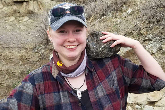
Sara McCullough
Professor Bryan Shuman, McCullough’s advisor, has long been working on capturing more of the story. He is a paleo-climatologist, which means he studies past climate, especially as it affects water. Shuman: “Water availability changes constantly because of climatic factors. Past conditions were often much drier than today’s, which highlights the risk of shifting into nearly permanent drought again in the future.” Ongoing work in Shuman’s lab focuses on documenting and mapping changes in the levels of lakes throughout North America over the past 15,000 years. Relating them with data on vegetation and fires, archeology, and climate model simulations, he strives to document patterns of climatic variation relevant to anticipating future changes and their impacts.
Sara McCullough heard about his work from a friend and joined the lab for her graduate studies. Not too far from her hometown Powell, she found her study lake. Its location in one of the easternmost ranges of the Rockies means it is influenced by the Great Plains climate, which is dominated by summer rain, and the western mountains climate, dominated by winter snow. A year-round creek that provides an inlet and outlet makes the lake sensitive to drier conditions and attractive as a study object.
When McCullough determined the water-level changes of Lower Paintrock Lake she found the level did not rise and fall according only to the surrounding temperature. Another factor must have been at play: precipitation. Sara explains: “Climate models are great at predicting temperature, but not so good for moisture.” Yet.
The sands of time
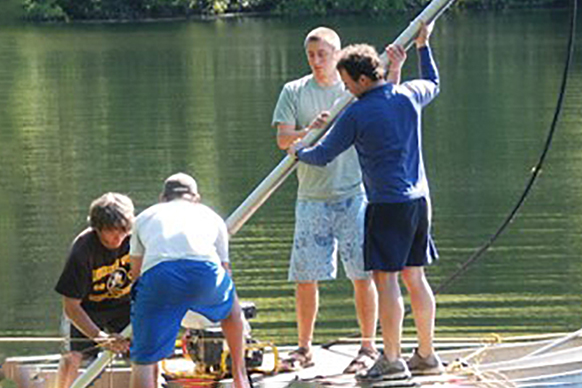
Bryan Shuman and students taking core samples
Now let’s look into how these prehistoric lake levels can be reconstructed. Scientists are making use of the fact that lakes have a sandy shore and more muddy ground the deeper the water gets. Determining the presence of sand is a direct measurement of the shoreline position through time, which makes it possible to calculate water depth at the lake center. The best spots to take samples are therefore areas that show alternating layers of mud and sand because they sometimes were underwater and sometimes formed the shore.
McCullough had already worked with sediment during her undergraduate time, but mainly from rivers. At the UW lab, she halved the tubes containing the lake bottom layers, cut the contents into cubes the size of sugar cubes and analyzed them for their sandy content. It’s painstaking detail work, but McCullough assures she enjoys the lab work as well as being in the field. She explains the results: “Wherever sand was present, we knew the water level was lower at that time.” Embedded charcoal bits helped to date the layers. Timing and magnitude of these layers made a lake level reconstruction possible.
Four layers of sand meant that Lower Paintrock Lake has experienced four low periods in the last 14,000 years, each about 3,000 years apart and lasting hundreds of years. These results aligned with earlier findings from the Rocky Mountains. Up until 3,000-2,000 years ago the region was much drier than today. The region was drier than during the Dust Bowl of the 1930s, more severe than anything in the historical record.
The missing piece
Back to the models. Climate varies on an annual scale as we witness in our very lives. Hot summers follow cooler years, rainy years alternate with drier ones. We also know that climate varies on longer time frames that can span millions of years – think multiple ice ages. But there might be a third rhythm in temperature change, a fluctuation on the timescale of a few thousand years. This might be overlaying the long-term trends we are currently using, leading to the differences between model prediction and observation.
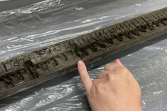
Prepared core from Lower Paintrock Lake
Just like temperature, moisture might vary on a millennial scale. Other lake levels that Sara McCullough compared to her study lake show very similar patterns and strengthen the hypothesis that droughts do not just last years or decades, but that they can extend for hundreds or thousands of years.
Understanding these millennial scale events might reveal the missing element in the models. If we discover why the climate models do not accurately represent these persistent droughts of the ancient past, we can improve how they tell us about future water uncertainty. McCullough phrases it a bit more carefully: “It's worth investigating to see if this variability is what's leading to the model-data mismatch in the climate models for the Rockies.” For her PhD she will continue to work with lakes and unlock their contribution to improving our ability to making predictions on the future climate in Wyoming.
What we can say about the last millennia: Even though Wyoming is the 5th driest state in the US today, evidence suggests that the region is wetter now than it has been for much of the Holocene.
The University of Wyoming has earned its Research Level 1 (R1) status from the Carnegie Classification of Institutions of Higher Education, placing Wyoming's only four-year university with the top research universities in the United States.