Remote Sensing in Construction
AUTOMATED PROGRESS CONTROL USING TERRESTRIAL LASER SCANNING TECHNOLOGY
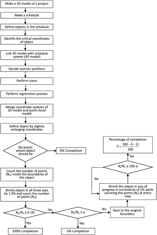
Assessing progress in construction activities is time-consuming and requires the use of specialized personnel. Automated progress control could reduce the workforce, the cost, and the time used, reduce disagreements, and add to the overall efficiency of project management. Attempts have been made in the past to resolve this issue using image processing and other techniques but the results have not been satisfactory. A new attempt is now made to set up a system that can assess progress control with minimum human input. An experiment makes use of laser scanning technology. The initial results appear to be promising but there are still obstacles to surmount. The system is robust and accurate in laboratory conditions and constitutes proof of concept. Improvements are necessary to accelerate the registration process of multiple scans, to recognize objects of irregular shape, and to assess the practicality and economic feasibility of such a system.

Phase 2 presents a practical automated method using laser scanning technology that can track the project’s progress in a real construction environment with limited human input. It is robust and accurate and is currently operational. The system capitalizes on the success of laboratory experiments. This system deals with occlusions effectively, accelerates the registration process of multiple scans, reduces the noise in the data, recognizes the objects of irregular shape, and is economically feasible. It provides evidence that all current challenges encountered in using laser scanners in monitoring construction progress can be overcome. This method has been successfully tested in the Wacker Drive reconstruction project in Chicago, IL.
IMPROVING TOLERANCE CONTROL ON MODULAR CONSTRUCTION PROJECT WITH 3D LASER SCANNING AND BIM: A CASE STUDY OF REMOVABLE FLOODWALL PROJECT
https://doi.org/10.3390/app10238680
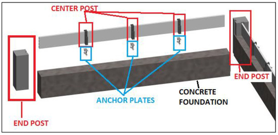
Quality control is essential to a successful modular construction project and should be enhanced throughout the project from design to construction and installation. The current methods for analyzing the assembly quality of a removable floodwall heavily rely on manual inspection and contact-type measurements, which are time-consuming and costly. This study presents a systematic and practical approach to improve quality control of the prefabricated modular construction projects by integrating building information modeling (BIM) with three-dimensional (3D) laser scanning technology. The study starts with a thorough literature review of current quality control methods in modular construction. Firstly, the critical quality control procedure for the modular construction structure and components should be identified. Secondly, the dimensions of the structure and components in a BIM model is considered as quality tolerance control benchmarking. Thirdly, the point cloud data is captured with 3D laser scanning, which is used to create the as-built model for the constructed structure. Fourthly, data analysis and field validation are carried out by matching the point cloud data with the as-built model and the BIM model. Finally, the study employs the data of a removable floodwall project to validate the level of technical feasibility and accuracy of the presented methods. This method improved the efficiency and accuracy of modular construction quality control. It established a preliminary foundation for using BIM and laser scanning to conduct quality control in removable floodwall installation. The results indicated that the proposed integration of BIM and 3D laser scanning has great potential to improve the quality control of a modular construction project.


USING TERRESTRIAL LASER SCANNERS TO CALCULATE AND MAP VERTICAL BRIDGE CLEARANCE
https://doi.org/10.5194/isprsarchives-XL-2-W2-133-2013
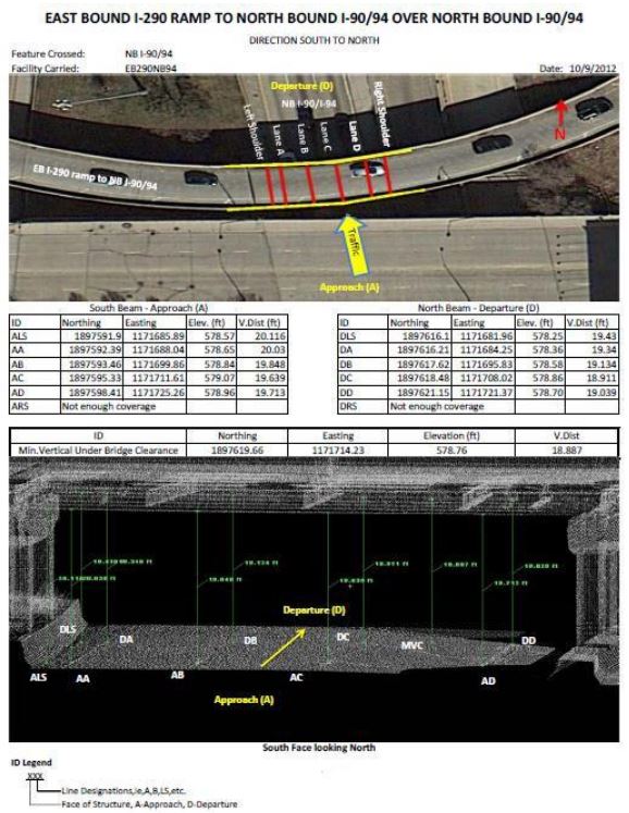
The vertical clearance of a bridge over a highway is important in preventing oversized vehicles from hitting the bridge. The vertical clearance of a bridge is traditionally measured by using surveying equipment such as leveling rods and total stations. Typically, measurements are taken at multiple locations in order to determine the minimum vertical clearance under the bridge. This process is time and labor consuming. Also, these measurements may not be accurate because of the traffic, the uneven surface, and the reading error caused by the surveyor. Additionally, when one is faced with a multitude of reports especially in large projects with multiple ramps and bridges, it is not easy and it often takes a long time to find the bridge under study. This research provides a highly accurate measurement of the vertical bridge clearance by using terrestrial laser scanners. The clearance can be measured in the office by processing the collected point cloud data. The minimum vertical clearance is easily identified and the measurement is visualized and geo-referenced. An approach to reduce data noise caused by traffic is also introduced in this study. In addition, to help reduce the confusion of finding the bridge under study and to facilitate access to the clearance data, the clearance measurements are geo-referenced to an online mapping system. This system allows access to the final deliverable very easily through a single web portal. Finally, Illinois Department of Transportation's Circle Interchange is used to demonstrate this new method


