Grasshoppers of Wyoming and the West
Entomology
Wyoming Grasshopper Population Dynamics Maps
Infestation expansion 1978-79 map
from Chapter II of Spatial Analysis of Ecological Factors Related to Grasshopper Population Dynamics in Wyoming

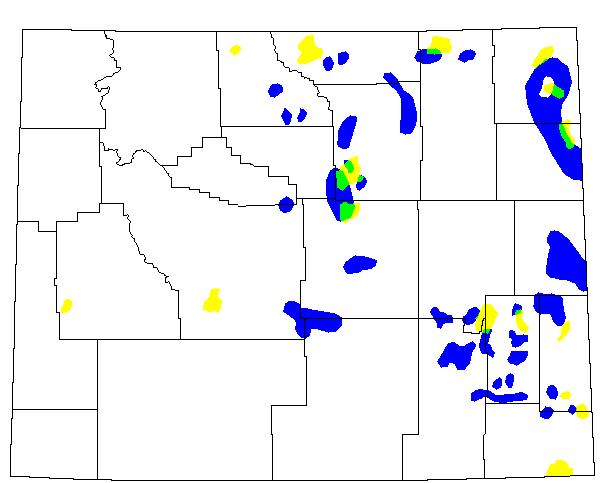
Fig. 16. Spatial distribution of rangeland grasshopper outbreaks during 1978-1979, when the infestation area increased by 331.3% over the previous year (dark shading = uninfested area; yellow = area infested in 1978 only; blue = area infested in 1979 only; green = area infested both years; black = state and county borders).
Back to Wyoming Grasshopper MapsLEARN MOREGrasshoppers of Wyoming and the West Field Guide to Common Western GrasshoppersWyoming Distribution AtlasWyoming Grasshopper Information System (WGIS)Key to Wyoming Grasshoppers Wyoming Grasshopper MapsGrasshoppers of Colorado Reduced Agent and Area Treatments (RAATs)Grasshopper LinksRangeland Grasshopper Management
LEARN MOREGrasshoppers of Wyoming and the West Field Guide to Common Western GrasshoppersWyoming Distribution AtlasWyoming Grasshopper Information System (WGIS)Key to Wyoming Grasshoppers Wyoming Grasshopper MapsGrasshoppers of Colorado Reduced Agent and Area Treatments (RAATs)Grasshopper LinksRangeland Grasshopper Management