News & Events | WyGISC


Ramesh Sivanpillai

Featured Story

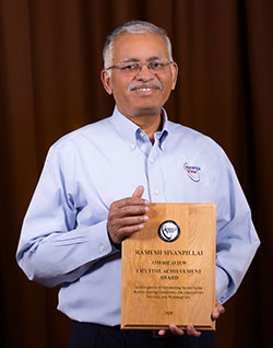
UW Instructional Professor Receives Lifetime Achievement Award from AmericaView

April 30, 2025

For years, Ramesh Sivanpillai has been called upon to handle remote sensing analysis after major disasters that include fires, floods and hurricanes. The University of Wyoming faculty member was recognized for his longtime work, which includes teaching and mentoring 200-plus students in remote sensing applications, when he recently received a Lifetime Achievement Award from AmericaView.


Top Stories

Sivanpillai Receives UW’s George Duke Humphrey Distinguished Faculty Award

Whether it has been teaching, research, educational outreach or responding to national disasters, Ramesh Sivanpillai has answered the call.

Featured Story

UW Researchers Contribute to UN’s Atlas of Ungulate Migration

The University of Wyoming’s Matt Kauffman, Shannon Albeke and William Kirkpatrick were among 80 worldwide scientists who contributed to a United Nati...

Featured Story

UW’s Hamerlinck Leads University Consortium for Geographic Information Science

Jeff Hamerlinck, University of Wyoming School of Computing associate director and senior research scientist, has become president of the University C...

Events

Inaugural Geringer Distinguished Lecture April 29 at UW

Jim Geringer, Wyoming’s 30th governor and former director of policy and public-sector strategies at the Environmental Systems Research Institute, is ...

This Week at UW

UW Researchers Lead Team to Produce New ‘Ungulate Migrations of the Western United S...

A new set of maps that document the movements of ungulates is now published in the fourth volume of the “Ungulate Migrations of the Western United St...

Featured Story

UW’s Yang Wins NASA Grant to Study Land Use and Fire in Western US Forests

University of Wyoming School of Computing Assistant Professor Di Yang has been awarded a NASA Early Career Investigator Program grant to study how la...

Top Stories

Woolpert Contracted by University of Wyoming to Produce Digital Terrain Model and Contours

WyGISC at UW has tasked Woolpert with producing a higher-resolution digital terrain model and contours covering the entire land area of...

Featured Story

UW’s WyomingView Trains Student Interns in Remote Sensing

This past summer, the WyomingView program crossed a major milestone. The program, which trains the next generation of remote-sensing scientists and e...

Top Stories

UW Research Scientist Part of Pecora Group Award

A University of Wyoming senior research scientist is part of the AmericaView consortium that was recently honored with a 2021 William Thomas Pecora G...


Events

Check out WyGISC's YouTube channel for the lastest Geospatial Forum presentations


Find us on Instagram (Link opens a new window)Find us on Facebook (Link opens a new window)Find us on Twitter (Link opens a new window)Find us on LinkedIn (Link opens a new window)Find us on YouTube (Link opens a new window)