Generally, most methods focus on the assessment of the ecological integrity of wetlands. There is general acceptance of ecological integrity as a conservation goal, and over the past three decades, many methods have been developed to evaluate the complex ecological condition of freshwater ecosystems using observable field indicators that produce cumulative condition scores that inform ecosystem management.
However, it is important to understand the difference between methods that assess “function” versus those that assess “condition”. Functional assessments generally focus on the capacity of a wetland to perform specific functions, for example, biogeochemical cycling or hydrologic storage, whereas condition assessments provide an integrated score for overall “ecosystem integrity” in which the functional capacity is inferred. The intended application of the data and endpoint should inform which method is appropriate.
Assessment Framework and Metrics
Many mechanisms to protect, manage, and restore freshwater systems depend on the accuracy, efficiency, and defensibility of assessment data. Currently, a three-tiered approach to wetland assessment is recommended by the U.S. EPA, with each tier increasing in degree of effort, cost, and scale:
Level 1 assessments, or wetland profiles, are broad in geographic coverage and are used to characterize land use and the distribution of resources, such as wetland types, across the landscape. These assessments primarily utilize digital information or remote sensing data in a Geographic Information Systems to provide a “desktop analysis” of wetlands at the landscape scale.
Level 2 assessments evaluate the condition, function, or state of individual wetlands using field-based methods that focus on indicators, including anthropogenic disturbances, also known as stressors, which are rapid and easy to measure. Level 2 Rapid Assessment Methods (RAMs) are used throughout a number of regions in the USA because they provide an on-site assessment of wetland condition, function, or state with relatively little effort. Common RAMs estimate the ecological condition, function, or state of the wetland landscape by integrating metrics that focus primarily on hydrology, and physical and biological structure. RAM metrics focus on observable stressors and disturbances known to degrade the ecological integrity or function of wetlands. Field sampling generally takes 2-4 hours to complete.
Level 3 assessments utilize more intensive methods, such as measure of diversity, to collect quantitative field data. Types of level 3 data include plant and animal species lists, macroinvertebrate sampling, soil profile characterization, and water quality measurements. Field sampling generally takes 6-8 hours to complete.
Recommended Protocols for Wetland Inventory and Assessment in Wyoming
Many protocols exist for wetland inventory, monitoring, and assessment. WYNDD recommends the following protocols based on their application to Wyoming wetlands, their ease of use, the quality and clarity of their methodology, and their utilization and validation. Please use the flowchart and table below to identify the protocol most suitable for your purposes.
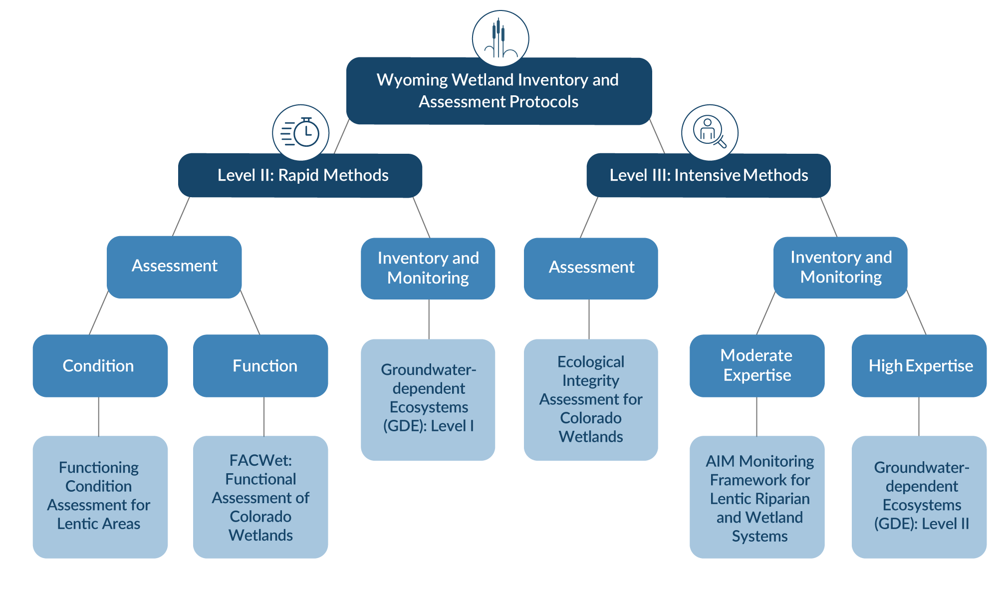
Follow the links below for the Protocols listed in the image above:
- Functioning Condition Assessment for Lentic Areas
- FACWet: Functional Assessment of Colorado Wetlands
- Groundwaterdependent Ecosystems (GDE): Level I
- Ecological Integrity Assessment for Colorado Wetlands
- AIM Monitoring Framework for Lentic Riparian and Wetland Systems
- Groundwaterdependent Ecosystems (GDE): Level II

*The text above is excerpted from the following report, which provides a thorough review of wetland monitoring and assessment in Wyoming:
Tibbets, T., Washkoviak, L., & Tronstad, L. 2020. Wetland Monitoring and Assessment in Wyoming: Addressing the Challenges of Wetlands in Highly-Managed Basins. Wyoming Natural Diversity Database. https://www.uwyo.edu/wyndd/_files/docs/reports/WYNDDReports/20tib01.pdf