Published February 20, 2025
By Sean Bertalot and Tristan Blechinger
This two-part blog post is adapted from a presentation held in December 2024. Presenters and authors: Sean Bertalot, student with Sarah Collins studying limnology and ecosystem ecology in Jackson Lake. Tristan Blechinger, student with Willie Fetzer studying fisheries, food web ecology in Jackson Lake and elsewhere.
"In this blog post, we will talk about ecosystem production and food webs in Jackson Lake. Then we’ll expand on some future work that we're both working on as a joint project about mapping aquatic habitats.
Lake zones
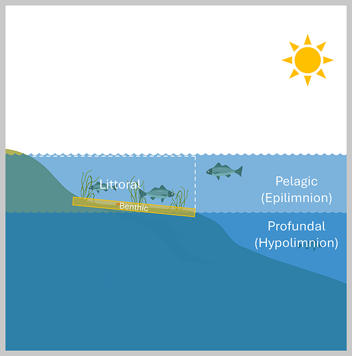
Sean Bertalot: "Let’s start out with some terminology. Down deep, the bottom layer of water in a lake system is called the profundal zone, or the area where sunlight is not penetrating the water column. We also call it the hypolimnion because this layer of water is colder than the ones above. The open water area where light penetrates the water column but does not reach the bottom of the lake is known as the pelagic zone. We also call this the epilimnion because it is the warmer layer of water on top.
The main focus today is the littoral or near shore zone, the area where light penetrates the water column and actually reaches the bottom. The benthic zone is critical habitat for most aquatic species, especially fish. Benthic algae and plants provide food and shelter for young fish and smaller organisms, which in turn draw in larger fish. The nearshore zone, and associated benthic zone, is a uniquely sensitive part of the lake ecosystem, sitting at the interface between terrestrial and aquatic landscapes. Anything coming off the landscape flowing into the lake is going through the littoral zone before reaching it and reaching out to deeper areas of the lake or reservoir. It is a hotspot for primary productivity with algae and plants producing a lot of oxygen, and it is the highest area of biodiversity within the lake ecosystem.
A lot of Wyoming systems are reservoirs, artificial lakes characterized by controlled drawdown. Drawdown can be impactful to the littoral zone; a small amount of drawdown depending on how steep the lakebed is can have a small effect on the actual area, but larger drawdowns can have much more drastic effects and really shrink the available nearshore area. Drawdown also makes it harder for plants: fluctuating water levels make it hard to survive, or to recolonize.
It is not only the physical water level fluctuations that impact this area. Sediments and nutrients come in off the landscape, which can reduce the clarity of the water, thus shrinking the zone and making it harder for these aquatic plants to grow. Runoff can also spur algal blooms, which choke out aquatic plants and decrease water clarity. These processes are not mutually exclusive; all of them can happen at the same time, which has direct effects on the available habitat in these reservoir systems."
Tristan Blechinger: "One project that Sean and I are working on together is mapping the bathymetry of Wyoming reservoirs so we can quantify how habitat availability is changing with water level fluctuations. We are focusing primarily on the near shore littoral area where benthic algae, macroinvertebrates, and aquatic plants promote high species richness and productivity, and also the volume of open water habitats like the epilimnion (warm water) and the hypolimnion (cold water), which all play important roles in the aquatic ecosystem.
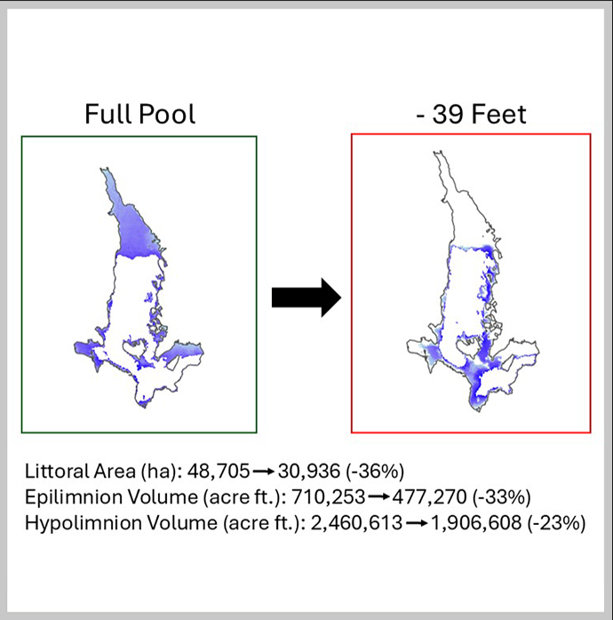
Over the past summer, we mapped Jackson Lake to put together a high-resolution bathymetry or depth map. We paired that with a measure of water clarity, averaged out across the season and across the lake, to estimate the extent of the littoral zone at various water levels. This allows us to quantify the amount by which each of these unique habitats will vary as water levels are drawn down.
From full pool to maximum drawdown, which in Jackson Lake is 39 feet, we see a loss of about 1/3 total area of the littoral habitat. Along with that, we see about a 1/3 loss in the warm water habitat volume and around 23% loss in the cold-water habitat volume.
We are currently working to expand this project to other reservoirs across Wyoming and are developing a web app that will be available to the public and serve as a tool for managers, anglers, and other members of the public to understand how reservoirs are changing as water levels fluctuate."
Sean Bertalot: "My field season in 2024 was designed around a central question: How does ecosystem metabolism vary between different habitats in a large reservoir?
Let’s back it up for a second... What is ecosystem metabolism? Why is it an important metric to track? The best way to think about ecosystem metabolism is that it is a measurement of how the system breathes. Everything in a lake, from the fish to the bugs, and even the plants and algae to a lesser extent, takes in oxygen and breathes out CO2. The CO2 produced by respiring organisms is then integrated by photosynthetic organisms (like plants and algae) which then use it to create energy, producing oxygen as a byproduct. Unlike land ecosystems the lake system is contained, almost like a closed Tupperware. Because of this, we researchers can use sensors deployed on buoys to track the daily changes in oxygen. To push the metaphor just a little more: The daytime is like a big deep breath for the lake, with the sunlight drives photosynthesis which produces large quantities of oxygen. At night, photosynthesis slows down, and the lake exhales, producing more CO2 which then is used the next day. By tracking these fluxes, we can better understand how energy flows through the system, energy that is essential for all other organisms to live and grow.
Our main goal with this project was to address knowledge gaps in current scientific literature. Most lake studies focus on one single site, located at the deepest part of any given lake. Studies have shown that without additional sensors, the estimates taken from these sites are not representative of the whole lake. Indeed, lakes can have a variety of habitats across their surface. We set out to understand how ecosystem metabolism varied across the multiple different habitats present in Jackson Lake.
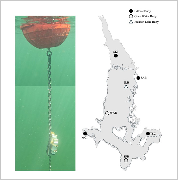
To accomplish this, we put out seven oxygen sensors, as well as temperature and light loggers, which are three of the essential ingredients for measuring oxygen production. Four of the sensors were deployed in shallow water across a habitat gradient. One was in the north end of the lake, an area that typically has lower water clarity because of the Snake River input. Two were situated in shallow habitat in sheltered bays, each bay fed by a smaller stream with differing water temperatures. The final shallow buoy was set in an exposed, south region of the lake. The 3 deep buoys were staggered from north to south. All buoys collected data at 10-minute intervals throughout the summer. Additionally, we conducted weekly samples for chlorophyll-a (a proxy for algae biomass), as well as total nitrogen and total phosphorus.
This approach produced a lot of data, which is great news! Unfortunately, it takes an equally large amount of time to process all this data and garner meaningful results. So, while we don’t have much to share on that front right now, we’re excited to share what we find very soon."