
Buoy on Jackson Lake
Published March 07, 2025
By Kevin Gauthier
Kevin Gauthier: “I'm a research technician for WyACT’s Aquatics team and joined the project about two years ago. Our team collects data on lakes and rivers in northwest Wyoming to establish a baseline understanding of water quality and ecology in these data-poor ecosystems. We plan to use the data to inform models of both present and future conditions within these lakes and rivers. In order to learn anything about long term trends, we need to start clocking data now!
We focus on three lakes: Jackson Lake, Boysen Reservoir and Brooks Lake. We use three methods of data collection: buoys, a system called FLAMe, and more traditional, manual lake monitoring efforts. These approaches can complement one another as we are thinking about these lake ecosystems as a whole.
Monitoring buoys are stationed at a single point on each lake. They record data every 10 minutes, resulting in a high-resolution time series of variables like temperature and algae growth. Temperature and the biomass of algae impact habitat, recreation and water quality in these three lakes. Once deployed, the buoys work independently all summer. They transmit information remotely, so we can use them to display water quality data to managers and community members in real time. We have observed algae blooms in real time on Boysen Reservoir and Brooks Lake, whereas Jackson Lake has shown minimal algae growth.
The buoys are fixed at one point, limiting their ability to assess the physical habitat and water quality across the entire surface of the lakes. Our research team is interested in what the buoy measurements may be missing, particularly across large water bodies like Jackson Lake and Boysen Reservoir. To address this knowledge gap, we use an instrument called the FLAMe (Fast Limnological Automated Measurements) mounted on a boat. It pumps water from the lake through tubes and various sensors as you drive across the lake. Data are recorded every second as you drive and are linked to a GPS, resulting in a map of surface water chemistry across the whole lake.
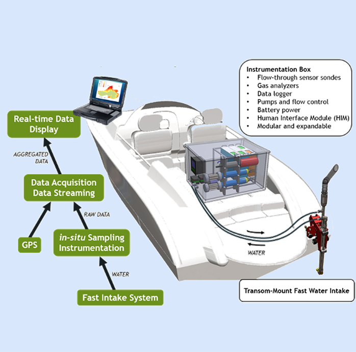
Schematic FLAMe setup on a boat
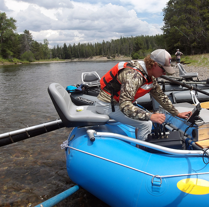
FLAMe in operation
Measurements collected by the FLAMe system give us an idea of how well our buoys stationed on Jackson Lake and Boysen Reservoir represent conditions across the whole water body. We see that on any given day, temperature varies across the surface of the lake. In June, for example, Moran Bay in Jackson Lake was colder than the warmest areas close to the dam or the Snake River inlet. In August, however, the lake was coldest near the Snake River inlet and generally warmed as we moved closer to the dam. In June we observed almost a six-degree variation in temperature across the lake surface, and in August almost a three-degree variation, suggesting that localized factors like river inlets (Snake River, Moran Creek, etc.) must be driving spatial differences across the lake surface.
In Boysen Reservoir, we observed changes in both temperature and algae growth across the surface. One day in June, for example, we saw a five-degree temperature variation across the surface of the lake and very patchy algae growth: minimal in the northern half, but considerable in the southern end near the Wind River inlet. As we sampled again in August and October, we saw algae growth shift to different bays of the reservoir. If we relied only on data from a single location, our understanding of how water quality changes throughout the year would be incomplete.
Both seasonality and spatial variation are important in understanding water quality in these lake and reservoir ecosystems. By using buoys to capture seasonal trends and the FLAMe system to capture the whole water body surface, we create a more complete picture of what's actually going on in these ecosystems.
A final dimension of lake water quality and ecology that our research team hopes to understand involves considering the whole water column rather than just the surface. That's where we loop in some of our traditional lake monitoring approaches that include sampling at different depths. Temperature varies with depth, as anyone who has dove under the surface while swimming in a lake to feel the rapid temperature change could tell you, as does the growth of algae. In Jackson Lake, we find the highest density of algae anywhere from 5 to 13 meters (16 to 42 feet) deep. While we are sampling with the FLAMe system at the surface, we are missing the algae growing down deeper, and our limnological monitoring helps capture that.
We have integrated various data collection approaches on lakes and reservoirs in northwest Wyoming to establish a baseline understanding of the water quality and ecology of these regionally important water bodies. As we continue to expand our data collection efforts, we hope to better understand how these ecosystems may change in the future."