

Project Lists:
UW Division Of Administration
Project Dates: 1 July 2014 - 30 July 2014
Funding Sponsor: UW Division of Administration - Real Estate Operations
Principal Investigator: Wendy Berelson
Co-Investigator(s): Jeff Hamerlinck
Project description:
WyGISC, in cooperation with the University of Wyoming Real Estate Operations (REO), has developed a GIS to organize and track the university's real property transactions including acquisitions, disposals, easements, leases and associated data (e.g. deed documents). The GIS data resides in an Arc Spatial Data Engine (ArcSDE) database. Data can be accessed via WyGISC's GeoData Applications Portal which contains customized web-based applications. Additionally, under the auspices of this project WyGISC has been working with other departments within the Division of Administration including Physical Plant.
Web-based applications were developed to increase the efficiency of real estate administration using state of the art GIS technologies including: ArcSDE and ArcGIS Server. These applications provide the ability to access and query spatial and related data about the university's statewide, national and in some cases international property holdings and improvements (i.e. buildings, parking and statues).
These ArcGIS Server based web applications are available via the secure GeoData Applications Portal. The Real Estate Viewer (REV) created using Adobe Flash allows administrators and others with access, query and display REO property data details including documents and photos. The Campus Control Network Viewer provides UW and contractors with the ability to view locations of and detailed information about survey control points on campus.
Two other applications were created for Physical Plant. The Lease Maintenance Viewer allows the user to view who is responsible for maintenance of buildings and grounds that are leased to or from the university. The Utilities Viewer is an application to query and display Physical Plant's utilities data. More recently, an application was developed to view UW's emergency phone and automated defibrillators (AEDs) on campus. This application also allows for viewing the floor plans/emergency information for buildings on campus.
Walnut Gulch w/channel morphology
The University of Wyoming owns an Optech ILRIS 3-D laser scanning system. This system is designed to be run by a single operator, operates at 1500nm wavelength (eye safe) and has a resolution from <10 mm to +10 m with accuracy of ~ 7mm @ 100m range.
Urban forest characterization project / Tree canopy project
Urban planners and foresters are increasingly interested in the amount, location and condition of trees in the city. A procedure has been developed that uses digital color orthophotos and LiDAR data to map and evaluate the urban forest resource more accurately. The LiDAR data is used to identify objects based on a height threshold.
The tree canopy map was prepared by using industry standard best procedures for determining object heights from LiDAR data, coupled with the use of an ancillary infrastructure layer to edit out tall objects that are not trees.
Little Laramie River Project
WY focuses on the use of airborne LiDAR to quantify topographic detail that will aid in the understanding of why The Laramie river is anastomosing.
Landcover mapping, ground-based, Laramie project
The high resolution images from satellite platforms are well suited for landcover classification. When coupled with high-resolution DEM (LIDAR), the classification accuracy is increased for woody vegetation.
Eli Rodemaker
Scott Miller
Project Dates: 1 September 2007 - 28 February 2009
Funding Sponsor: U.S. Geological Survey
Principal Investigator: Jim Oakleaf
Other Personnel: Shawn Lanning, Teal Wyckoff
Project Summary:
The Wyoming Geographic Information Science Center (WyGISC) main objective for this grant was to provide the public with the ability to download the 2006 NAIP photography on a USGS quadrangle basis. In order to accomplish this task, it was necessary for WyGISC to mosaic all four uncompressed DOQQs for each quadrangle and then clip these data to the extent of the representing USGS quadrangle. Additionally, for distribution purposes, each new quadrangle image needed to be in a compressed image format and then packaged with the necessary metadata and projection files. Once this process was completed for all of the 1938 quadrangles covering Wyoming, it was necessary to create an application to aid in data access. All of the above-mentioned steps were completed within the last year and half with access to these data available through the WyGISC Imagery Server.
Publication:
Oakleaf, J.R. 2009. Final Report: 2006 NAIP Data Distribution Application. For: U.S. Geological Survey.
Project Dates: October 2002 - October 2004
Funding Sponsor: U.S. Geological Survey - Biological Resources Division
Principal Investigator: Nathan Nibbelink
Co-Principal Investigator: D. Schrupp (Colorado Division of Wildlife)
Project Summary:
The GAP analysis program proposes to take a geographic approach to planning whereby environmental layers are used to create broad-scale GIS maps of potential habitat for native species and, in addition, GIS data representing the current protection status of the land intersecting these species ranges allow managers to plan for species protection and habitat protection/restoration at broad, ecologically significant scales. This project uses a two-pronged effort to develop Aquatic GAP methodologies across the Colorado/Wyoming state line. 1) For a set of pilot watersheds in the South Platte River basin, apply Aquatic GAP techniques to aid in completion of the Missouri River Aquatic GAP program, and 2) Assess multiple approaches to developing robust species distribution models for 3 species in these watersheds. It is hoped that this pilot study will outline the costs and protocols for broader scale application of Aquatic GAP analysis in Wyoming and Colorado.
Project Dates: 1 July 2002 - 31 December 2004
Funding Sponsor: Department of the Interior, Bureau of Land Management
Principal Investigator: Jeff Hamerlinck
Co-Principal Investigator: Jim Oakleaf
Project Summary:
The project scope consists of the creation of a centralized Internet-based clearinghouse for textual, tabular, photographic, and spatially-referenced information pertaining to coalbed methane resource development and related management issues in Wyoming. The ultimate goal of the project will be to create and maintain a single, up-to-date, and easy-to-use entry point for accessing data and information on all aspects of CBM-related issues in Wyoming. Target audiences will include resource management agencies, industry, non-governmental organizations, and the general public. The development of an information infrastructure of this kind has the potential for quickly becoming very large in scope and difficult to manage and maintain. The proposed scope of the Wyoming CBM Clearinghouse will initially focus on Wyoming's Powder River Basin, which will result in a scalable Web-based product suitable for expanding coverage and an accompanying implementation plan for achieving that goal in the future.
Project Dates: 17 September 2001 - 31 March 2005
Funding Sponsor: Department of the Interior, Bureau of Land Management
Principal Investigator: Jeff Hamerlinck
Project Summary:
WyGISC in partnership with the State of Wyoming Bureau of Land Management Office created and implemented one of the first ever ArcView IMS applications. This application named the Wyoming Oil and Gas Resource Assessment (WOGRA) tool provides industry and regulators the ability to view and query geospatial data related to oil and gas development and the resources affected by this development. Currently efforts are ongoing to migrate this application into the more current ESRI Internet technology, ArcIMS.
Project Dates: 1 July 2006 - 31 December 2009
Funding Sponsor: Wyoming Game and Fish Commission
Principal Investigator: Ken Driese, Jeff Hamerlinck
Project Report: University of Wyoming Central Wyoming Remote Sensing Project Final Report (pdf)
Project Summary:
The Wyoming Geographic Information Science Center (WyGISC), funded by the Wyoming Game and Fish Department and USDI-Bureau of Land Management, in partnership with USDA-Natural Resources Conservation Service and Forest Service, USDI-Fish and Wildlife Service and Bureau of Indian Affairs, and Chicago Botanical Gardens is conducting an extensive mapping project for Western and Central Wyoming. Employing a collaborative implementation approach the project entails three major mapping goals; current land use and land cover distribution, modeling of snow cover distribution for high and average snow accumulation winters, and spatially explicit land use and land cover change detection. Mapping goals are divided into three overall project areas with initial emphasis on Southwest Wyoming including the Upper Green River Basin, then the Wind River Basin, and finally the Bighorn Basin. Synopses of project goals are described in the following paragraphs.
Land Cover and Land Use Mapping: Project efforts initially are focused on an eastern area of the Upper Green River Basin within Sweetwater County. Other areas within the Upper Green have been mapped by BLM. Building on concepts employed in mapping areas of Southeast Wyoming the team endeavors to create a map suitable for multiple land management activities including habitat distribution and assessment. Mapping techniques rely on concepts of potential natural vegetation modeling modified with the current condition perceived by the Landsat imagery. Further, the field reference sampling protocol seeks to improve knowledge of the ecological systems and associated vegetation communities within Wyoming, as well as land use pattern and impact. Vegetation mapping is performed by combining terrain analysis techniques with the biophysical properties or condition sensed by the Landsat imagery. Land use mapping employs a myriad of GIS, photo-interpretation and remote sensing techniques. The protocols are heavily field sample based in order to develop statistics describing the range of terrain and vegetation types and conditions, including estimates of vegetated cover. By developing the classification categories and populating the necessary statistical inferential knowledge from ground reference (inventory) the project employs a ‘bottom-up' protocol. Each field visitation site catalogs spatial description, terrain information (including Munsell soil color), floristic typing and abundance, as well as perceivable disturbance and impact from natural or man-made occurrences. Spatially explicit GIS data, tabular data, and site digital photographs embody a field reference site dataset. From this sample dataset, statistics of environmental gradients and terrain features, as well as spectral properties from the remotely sensed imagery are compiled. These statistics are then modeled into a spatially explicit representation of land cover types and vegetation abundance (%cover/closure).
Finally, products from previous classifications were cross-walked into the new classification scheme identified from field sampling to provide synoptic coverage of the Upper Green River Basin and BLM management districts for the Kemmerer, Rock Springs, Pinedale, and Rawlins Field Office areas.
Change Detection: Change analysis is being performed to help identify areas undergoing natural and man-made change. Using a time series of Landsat imagery at 30m spatial resolution the project will identify areas experiencing disturbance or changes in vegetation abundance. Change will be mapped on a five year time step starting in 1985 proceeding to present (%7e2005/2006). Therefore change maps will be produced for the periods; 1985 to 1990, 1990 to 1995, 1995 to 2000, and 2000 to present.
Snow Cover Mapping: Landsat imagery was identified for two snow conditions; a period of average snow cover and high snow cover. Time periods were identified using Snow-Tel observation stations and deviation from 30 year normal and visual interpretation of atmospherically clear and available imagery dates identified from Snow-Tel. The selected imagery will be transformed into a spectral index of snow cover and binned into categories of no, full, and partial snow cover of vegetation/substrate.
Publication:
Rodemaker, E.L., and Driese, K.L. Mapping Land Cover Types Using Remote Sensing, GIS and Aerial Photography for the SW Wyoming, Pinedale and Green River Wyoming Game and Fish Department Regions. Final Report to: Wyoming Game and Fish Department. 7 May 2007.
Montane Land Cover: Pixel Level
 |
 |
Montane Land Cover Types:
|
01.10.1 Lodgepole Pine 20-32% closure
01.20.2 Douglas Fir 33-67% closure
01.30.3 Spruce-Subalpine Fir >67% closure
01.61.1 Limber Pine-Douglas Fir 20-32% closure
01.70.1 Whitebark Pine 20-32% closure
01.90.2 Mixed Conifer-Dominant 33-67% closure
02.10.2 Aspen 33-67% closure
03.21 Juniper-Sage
05.13.3 Mountain Big Sagebrush >25% closure
05.16 Wyoming Three-tip Sagebrush
05.33 Fringed Sage
07.30.1 Foothills Grassland 7.5-20% cover
07.60 Riparian/Wet Meadow
12.80 Snow |
01.10.2 Lodgepole Pine 33-67% closure
01.20.3 Douglas Fir >67% closure
01.60.1 Limber Pine 20-32% closure
01.61.2 Limber Pine-Douglas Fir 33-67% closure
01.70.2 Whitebark Pine 33-67% closure
01.90.3 Mixed Conifer-Dominant >67% closure
02.10.3 Aspen>67% closure
05.13.1 Mountain Big Sagebrush 5-15% closure
05.14 Black Sagebrush
05.17 Alkali/Early Sagebrush
06.10 Willow
07.30.2 Foothills Grassland 21-40% cover
10.10 Water-Lentic or Standing |
01.10.3 Lodgepole Pine >67% closure
01.30.2 Spruce-Subalpine Fir 33-67% closure
01.60.2 Limber Pine 33-67% closure
01.61.3 Limber Pine-Douglas Fir >67% closure
01.90.1 Mixed Conifer-Dominant 20-32% closure
01.94.2 Conifer-Aspen 33-67% closure
02.20.2 Aspen-Conifer Mix 33-67% closure
05.13.2 Mountain Big Sagebrush 16-25% closure
05.15 Mountain Silver Sagebrush 05.41 Bitterbrush-Sagebrush
06.20 Willow upland
07.40.2 Alpine Grassland 21-40% cover
12.40 Rock or Talus Slope |
Project Dates: 1 February 2009 - 31 December 2011
Funding Sponsor: Wyoming Game and Fish Commission
Principal Investigator: Eli Rodemaker
Project Report: Land Cover Classification and Mapping in the Big Horn Basin, Wyoming Final Report (pdf)
Project Summary:
The project consists of land cover change analysis of the Cody region of the Wyoming Game and Fish Department as well as Yellowstone National Park. The project also consists of five separate, see figure, mapping missions to create land use and land cover maps of the region. Intensive field sampling is used to generate models of land cover from remotely sensed imagery and environmental GIS layers.
TIME FRAMES
- Develop 'initial' preliminary land cover map of the Region from existing data with the focus on priority area one by March 2009.
- Use data collected to assess general accuracy in priority area one and identify problem areas/cover types requiring additional data collection by May 2009.
- Collect additional data for priority area one as time and funding allow. Initiate mapping and data collection in priority area two, three, and four summer 2009.
- Develop 'final' map of priority area one December 2009.
- Generate initial maps of priority areas two, three, and four by April 2010 as time and funding allow.
- Use data collected to assess general accuracy in priority areas two, three, and four and identify problem areas/cover types requiring additional data collection by summer 2010 as time and funding allow.
- Develop 'final' map of priority areas two, three, and four by April 2011 as time and funding allow.
Pending additional funding and information the project will be amended to include the following:
- Develop an' initial' map of priority area five by April 2010 using existing data sources.
- Collect additional, including field, data for priority area five by November 2010. Develop initial ‘final' map of priority area five by February, 2011.
- Use data collected to assess general accuracy in priority area five and identify problem areas/cover types requiring additional data collection by May 2011.
- If needed collect additional data summer 2011.
- Develop final map December 2011.
Project Priority Areas:

Project Dates: 1 July 2006 - 31 December 2009
Funding Sponsor: U.S. Department of Energy and U.S. Bureau of Land Management
Principal Investigator: Jeff Hamerlinck, Diana G. Hulme, and James R. Oakleaf
Project Summary:
The Wyoming Energy Resource Information Clearinghouse (WERIC) was a prototype website dedicated to information about Wyoming's energy resources, including coal, coalbed methane, natural gas, oil, hydropower, uranium, and wind energy development. The site also included information on reclamation as well as research on energy development impacts on water and wildlife resources.
Focused on energy activities in Wyoming, WERIC included current research reports, events, and links to key energy-related agencies and initiatives. WERIC also included educational pages with a visual library of energy extractive activities.
WERIC was an expansion of the University of Wyoming's CBM Clearinghouse website created in 2003 by the Ruckelshaus Institute of Environment and Natural Resources and the Wyoming Geographic Information Science Center. This pilot project was the result of initial funding from the Bureau of Land Management and additional funding support from the U.S. Department of Energy.
The goal of WERIC was to address the continued need to share current energy-related data among agencies, industry, non-government organizations, and the public. WERIC included Web-based educational information, maps and spatial data.
The project scope consisted of the creation of a centralized Internet-based clearinghouse for textual, tabular, photographic, and spatially-referenced information pertaining to energy resource development and related management issues in Wyoming.
The ultimate goal of the project was to create and maintain a single, up-to-date, and easy-to-use entry point for accessing data and information on all aspects of energy-related issues in Wyoming. Target audiences included resource management agencies, industry, non-governmental organizations, and the general public.
Project Dates: September 2004 - August 2004
Funding Sponsor: U.S. Geological Survey - Biological Resources Division
Principal Investigator: Nathan Nibbelink
Co-Principal Investigator: D. Schrupp (Colorado Division of Wildlife)
Project Summary:
The purpose of this project is to intersect the streams and roads of the state of Wyoming to identify all crossings, link those crossings with basic information from the Wyoming Game and Fish Department stream database and the Wyoming Department of Transportation bridge database, to create a final geospatial dataset that can facilitate required environmental evaluation activities in both agencies.
Project Dates: 1 September 2009 - 28 February 20010
Funding Sponsor: Perry Institute for Marine Science and the University of Wyoming International Program
Principal Investigator: Jim Oakleaf
Other Personnel: Teal Wyckoff
Project Summary:
This project will focus on assisting the Perry Institute for Marine Science (PIMS) in utilizing geospatial tools to create a detailed renewable energy plan, which can be employed as a showcase for other facilities within the Bahamas, principally the Exuma Islands. It is the hope of the PIMS to provide other entities and investors the opportunity to see first-hand how their current and proposed facilities can harness these renewable energies specifically wind and solar and at what cost. PIMS recognized the potential advantage of utilizing GIS and GPS tools to conduct an initial inventory of their energy needs and requirements. To accomplish this, they have asked WyGISC to lead in the mapping efforts.
Framework Standards Education Training Materials Project
Project Dates: 1 October 2005 - 30 September 2010
Funding Sponsor: Federal Geographic Data Committee
Principal Investigator: Jeffery Hamerlinck
Other Personnel: Shawn Lanning
Project Summary:
The goal of this project is to develop training materials for the Framework Data Content Standards as specified under an agreement with the Federal Geographic Data Committee (FGDC). These materials are part of the FGDC's Future Initiatives directive to develop materials to support understanding and foster implementation of the National Spatial Data Infrastructure (NSDI) Framework Standards. Materials are being designed to give an overview of each standard and standard part for each of the 7 Framework Standards.
Presentations:
URISA Half Day Workshop August 2007
ESRI UC Paper Presentation July 2008
Project Dates: Fall 2005 - Fall 2006
Funding Sponsor: Exxon Valdez Oil Spill (EVOS) Trust Council
Principal Investigator: Nathan Nibbelink
Project Summary:
Changes in sea surface temperatures, nutrient fluxes, primary productivity, abundance and species composition of invertebrates and fishes in the Gulf of Alaska (GOA), whether dramatic or gradual, are likely to affect the coastal terrestrial landscape. Predation of spawning pelagic fishes in nearshore environments by coastal river otters (Lontra canadensis) provides a pathway for nutrient transport between sea and land, extending the resource shed of the terrestrial community into the ocean. Using the relation between abundance and distribution of fishes and otter density and behavior, we propose to develop a model that will forecast changes in coastal forest heterogeneity along the GOA with projected climate change. Input data will be based on output from climate-ocean-fish interaction models developed through GEM. Output data will be in the form of digital maps describing deposition of N and P along the coast based on the relations between fish and river otters.
Project Dates: FY 2006 - FY 2008
Funding Sponsor: National Science Foundation
Principal Investigator: M. Ben-David
Co-Principal Investigator: Nathan Nibbelink, C. Meyer, J. Gulledge
Project Summary:
As in human societies, the natural environment is connected through a wide range of transport, propagation and communication processes. Fluxes of energy and matter between ecosystems modify food web interactions and nutrient cycling, and affect the diversity of plants, animals, and other organisms. Spatial linkages of ecosystems may be interrupted, however, by disruption in transport processes through time. Thus, ecological processes at any point in space can be affected by past and present flows of energy and nutrients. In order to understand complex ecological processes such as these we must explore the spatial and temporal variation, or ecological topology, of such phenomena. River otters (Lontra canadensis) transport nutrients from sea to land by feeding in the marine environment and using latrine sites along the coast. Thus, the behavioral dynamics of coastal river otter populations provides an excellent model system to explore the effects of spatial and temporal variation in inputs of marine carbon (C), nitrogen (N), and phosphorus (P) to terrestrial plants and soil organisms. Sociality in otters is solely driven by the benefits of cooperative foraging on schooling pelagic fishes. Therefore, any changes in the abundance and distribution of these prey through global warming, pollution, or harvest, could change the transport of nutrients to otter latrines. Using stable isotope analysis and genetic markers we will quantify the variation of nutrient transport by river otters and explore its effects on the diversity of the soil microbial community, nutrient cycling, plant uptake of marine nutrients, diversity of plants, plant growth, flowering and fruiting success. After establishing these responses to the variation in otter fertilization, we will develop a spatial model that will evaluate potential changes to the terrestrial landscape based on the distributions of schooling fish, otter activity, and C, N, and P transport by river otters, in response to climate change.
Principal Investigators:
Scott Miller, Dept. of Renewable Resources
Paul Caffrey, Wyoming Geographic Information Science Center
GIS Analyst: Margo Berendsen, WyGISC
Project Summary:
Increasing demands to issue permits for CBNG (coalbed natural gas) energy development throughout Wyoming requires more efficient methods to evaluate environmental impacts. Utilization of models in support of decision making provides resource managers with defensible mechanism for management. AGWA is a GIS-based program that utilizes spatially distributed models for modeling runoff, erosion and other factors, helping resource managers address spatial complexities across local and regional scales and validate sound management practices. AGWA stands for Automated Geospatial Watershed Assessment, a tool that couples the power of GIS and spatially distributed hydrologic models. AGWA uses data on topography, vegetation, soils and climate as input to two models, SWAT and KINEROS2. Output includes surface runoff, sediment yield, sediment discharge and many other factors.
Modeling Past, Present and Future Scenarios: The Fortification Creek watershed (127,800 acres) is one of several pilot watersheds, selected because it includes a BLM special management area for critical mule deer winter range. CBNG development has been limited in this area because of the critical winter range.
-
PAST scenario: Land cover from 1992 was used with SWAT to model the watershed in the past, before CBNG development had occurred. Results: 25% of the watershed has runoff values > 94 mm
-
PRESENT scenario: As of 2006, over 1000 wells have been drilled within the Fortification Creek watershed. Well locations were buffered by 200 meters. A number of 30 m2 cells were selected at random from the buffered areas, equaling the area of the surface use disturbance as submitted to the BLM (the average disturbance per well was 1.4 acres.) In this scenario, 0.86% of the total area of the watershed is disturbed. Results: 44% of the watershed has runoff values > 94 mm
-
FUTURE scenario: Assuming full CBM development, a well every 80 acres, 1.4 acre disturbance was created randomly per 80 acres in non-developed areas, and combined with the present disturbance. In this scenario, 2.25% of the total area of the watershed is disturbed.
Project Summary:
CARAT (Computer-Aided Resource Analysis Tool) is a GIS-based decision support system used by BLM field office managers and resource specialists in NEPA environmental assessment and other resource management decisions. CARAT is based on ArcGIS software, customized specifically for field office use. It utilizes over 50 themes of spatial data to help field office staff assess and document recommendations for permit applications, such as construction of well pads, access roads, and pipelines. In addition, CARAT tracks these project-specific analysis and recommendations for cumulative impact analysis. CARAT is currently in use in the Pinedale Field Office Area, Wyoming since 2000 and the White River Field Office, Colorado since 2004.
For more information please download the project pdf.
The purpose of CARAT is three-fold:
- Provide an easy method for viewing GIS data specific to a BLM field office.
- Provide shortcuts for selecting and zooming to areas such as specific townships/sections, allotments, quadrangles and other GIS data. The easy access to data and related query shortcuts will assist in mapping, planning, and numerous other applications.
- Provide a set of tools for reviewing proposed actions according to NEPA. Adding and reviewing applications in a GIS environment will provide, over time, a comprehensive database for cumulative impact assessment as well as other planning applications such as resource management plans.
CARAT works in ArcGIS 9.x with an ArcView license. When you start CARAT, it opens ArcMap and accesses many databases specific to the BLM. CARAT has all the same functionality of ArcMap, plus the CARAT toolbar.
Here are descriptions for each of the buttons and menus on the CARAT toolbar:
-
CARAT tools: A menu with options for adding and reviewing applications; displaying data; creating a quick map; changing options and viewing the log file.
-
Applications: Opens a form with a list of all the pending applications available for review. This form also has a button for adding new applications.
-
Display data: Opens a form listing all the data specific to the BLM field office. Check data on to display it and view its description.
-
Zoom to...: Opens a form for selecting and zooming to specific features, such as townships/sections, allotments, quadrangles, or other sources.
-
Quick map: Opens a form for creating a quick map by prompting for a map title and a page size
-
EA query: Click on any action in the display, and the corresponding environmental assessment (EA) document will pop open.
For more information about CARAT, please contact:
Margo BerendsenWyoming Geographic Information Science Center
Phone: 307-766-2532
Project Dates: 2004 - June 2005
Funding Sponsor: F.E. Warren Air Force Base
Principal Investigator: Nathan Nibbelink
Other Personnel: Jim Oakleaf, Gary Beauvais
Project Summary:
The Wyoming Natural Diversity Database (UW) has performed a variety of natural resource inventory and research projects on F. E. Warren Air Force Base over the past 10 years. These projects form a comprehensive investigation of flora and fauna of management concern on the base. These projects are ongoing, and will extend valuable time-series data sets pertinent to threatened species, invasive weeds, and other biological management issues. Other consulting and research units have also performed natural resource research on the base, adding to a body of information that can assist base managers in avoiding adverse impacts to sensitive resources, and assure compliance with federal, state, and local laws and regulations. The results and conclusions of much of this research are currently scattered across a variety of hard-copy reports, university theses, and independent digital maps. In order to maximize the management utility of existing and future information, it is necessary to integrate it into a single, comprehensive, and spatially-explicit database.
Project Dates: 2 February 2009 - 20 November 2009
Funding Sponsor: National Park Service
Principal Investigators:
William Gribb - WyGISC Academic Affiliate
Scott Lieske
Co-Principal Investigator: Phil Polzer
Project Summary:
The Lewis and Clark National Historic Trail (LCNHT) was authorized by an Act of Congress (PL-95-625) in 1978. With the enactment of this law, a new era had begun to preserve and promote one of America's most significant historic events and the corresponding route in the western United States. This project is designed to assist the National Park Service in maintaining, updating and expanding the directional and interpretive information along the Lewis and Clark National Historical Trail and to provide the information and procedures that will be the foundation for a flexible spatial data collection and maintenance system. This system will provide the background and basis for long term Trail planning.
Project Dates: October 2001 - December 2005
Funding Sponsor: Bureau of Land Management
Principal Investigator: Nathan Nibbelink
Co-Principal Investigator: G. Beauvais, D. Keinath, P.I.'s on umbrella project for 73 vertebrate species
Project Summary:
This project is to generate summary documents and distribution maps and models outlining the distribution and status of 16 fish species on the Bureau of Land Management's Sensitive Species List for Wyoming. These species assessments represent the current state of knowledge for each of the species and rely heavily on primary sources (current literature/agency reports) and expert knowledge.
Project Dates: 1 February 2007 - 31 December 2009
Funding Sponsor: Wyoming State Engineer's Office
Principal Investigator: Fred Ogden, Nawa Raj, Eli Rodemaker
Co-Principal Investigators: Jan Hendrickx
Project Summary:
A pilot study effort to improve estimation and mapping of consumptive water use in the Upper Green River basin of Wyoming for the Wyoming State Engineer's Office Interstate Streams Division. In collaboration with the Engineer's Colorado River Coordinator WyGISC investigated techniques to map a key water use estimation variable EvapoTranspiration or ET. A spatially explicit modeling approach was selected using in-situ weather station data and remotely sensed imagery as inputs.
We chose a model in use by colleagues in the western US and internationally, METRICtm: Mapping EvapoTranspiration at high Resolution using Internalized Calibration. This report describes the process of model development at the University of Wyoming's Wyoming Geographic Information Science Center, deployment of supporting in-situ weather stations by the State Engineer's Office, and use of this station data with remotely sensed inputs from the Landsat5 satellite Thematic Mapper imager.
Spatially explicit estimates of ET for the Upper Green River basin were generated as a grid of data locations representing 30 meter by 30 meter orthogonal areas on the ground. This data is loaded and delivered in a spatially co-registered Geographic Information System for further analysis. Results represent a pilot or preliminary study level effort and are discussed in detail within; further analysis is suggested in the final section.
Project Report:
Publications:
Rodemaker, E.L., Driese, K.L. Modeling Consumptive Water Use in the GReen RIver Basin, Wyoming Using Remotely Sensed Data and the METRIC/SEBAL Model. Final Report to: Wyoming State Engineer. 30 June 2008.
Publication Date: 5/23/2004
Authors:
Ramesh Sivanpillai
D. Booth
Samuel Cox
Kenneth Driese
Submitted to: American Society for Photogrammetry and Remote Sensing Proceedings
Abstract:
The USDA-ARS is developing aerial methods for rangeland environmental assessment by acquiring very-large scale aerial (VLSA) imagery from which to measure ground cover. Their methods incorporate systematic sampling using regularly-spaced flight lines and image-acquisition intervals providing for statistically-adequate sampling such that initial and subsequent surveys can be compared in tests for ecologically-important change over time. Although VLSA promises to increase accuracy and decrease the costs of rangeland environmental assessments, further improvements in cost efficiency may be possible if dependable and reliable estimates can be obtained from space imagery. Therefore, the USDA-ARS is interested in developing ancillary remotely-sensed data sources to monitor large areas of rangelands more frequently. LANDSAT data were selected for its repeat coverage and spectral characteristics. Numerous studies have attempted to find some utility for LANDSAT in rangeland monitoring. However, these efforts have not focused on measuring ground cover. Through collaborative research, the USDA-ARS and the University of Wyoming are evaluating the utility of a multi-scale monitoring approach in Wyoming. First, we are analyzing the similarities and dissimilarities in the spectral data characteristics using multivariate statistical techniques. Issues related to spectral and spatial resolutions of the two data sources will be identified and their impact on the measurement of vegetation and bare-ground cover will be quantified. Finally, vegetation and bare-ground estimates obtained from the two methods will be compared. If the estimates are not statistically different, then LANDSAT can be used for such rangeland monitoring activities.
Publication:
Project Dates: 1 October 2008 - 31 December 2009
Funding Sponsor: Wyoming State Historic Preservation Office
Principal Investigator: Jim Oakleaf, Scott Lieske, Phil Polzer
Project Summary:
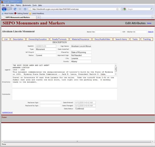
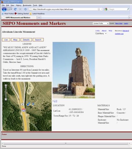
Project description (include project photo or graphic in email with this form) The Wyoming Monuments and Markers Program is a cooperative effort among the Wyoming Department of State Parks and Cultural Resources (SPCR), the Wyoming Department of Transportation (WYDOT), Wyoming Travel and Tourism, Wyoming Tribes, local governments, and private individuals and organizations. The Monuments and Markers Program installs new historical markers and maintains existing monuments, markers, and interpretive signage.
The objectives of this project are to design a new database that meets the needs of all participating organizations and migrate the current data into the new database. In addition, a new web based interface will be developed that will allow public access to the data as well as the ability to update and add content by the project coordinators and volunteers.
 |
 |
|
SHPO Monuments and Markers Web/Database Interface |
SHPO Monuments and Markers Content Example |
Project Dates: 1 March 2001 - 28 February 2005
Funding Sponsor: Wyoming NASA Space Grant Consortium
Principal Investigator: Johnson
Other Personnel: Ken Driese, Ramesh Sivanpillai
Project Summary:
The Wyoming NASA Space Grant Consortium funded this educational project to provide training to Native American resource managers on the Wind River Reservation (WRR) in central Wyoming. Workshops were conducted on the Reservation in December 2004 that emphasized the application of satellite imagery and other remotely sensed data to real management issues. Workshops included the fundamentals of remote sensing, and the integration of remotely sensed data into the existing GIS activities on the WRR. Workshops were taught by Sivanpillai and Driese of WyGISC and by Bill Gribb of the UW Dept. of Geography. Additionally, we provided a dedicated computer workstation and the Erdas Imagine image processing software to the WRR so that they can apply the skills learned in the workshops. We hope to continue these activities in future years.
Project Dates: May 2005 - May 2006
Funding Sponsor: NatureServe
Principal Investigator: G. Beauvais
Other Personnel: D. Keinath, Nathan Nibbelink
Project Summary:
Modeling potential habitat for plant and animal species is critical for evaluating threats to critical habitat and for broad-scale environmental planning. The Wyoming Natural Diversity Database (UW) and the Wyoming Geographic Information Science Center (UW), in cooperation with NatureServe (Arlington, Virginia), is producing a software tool that will facilitate element distribution modeling (EDM). The tool will organize and present the steps necessary to produce robust and usable models, perform the most crucial steps including implementation of multiple modeling algorithms, and map model output, all in a computer environment that assumes minimal knowledge of GIS and statistical programming by the user. The tool will primarily target personnel within the network of Natural Heritage Programs and NatureServe, but will become accessible, and perhaps invaluable, to a wider array of users.
Project Dates: 1 October 2004 - 31 May 2004
Funding Sponsor: US Department of Agriculture Natural Resources Conservation Service
Principal Investigator: Jeff Hamerlinck
Other Personnel: Jim Oakleaf
Project Summary:
WyGISC in partnership with the Natural Resources Conservation Service is working toward creating desktop and internet tools to assist with compliance of the Endangered Species Act, Clean Water Act and Historic and Preservation Act. The desktop tools will be created using ArcObjects and be available for NRCS employees using ArcGIS. The Internet tools will be created using ArcServer Technology and will provide dynamic HTML reports detailing possible resource disturbances for an NRCS project.
Project Dates: 1 January 2010 - 31 July 2011
Funding Sponsor: Pathfinder Renewable Wind Energy, LLC
Principal Investigator: Eli Rodemaker
Project Summary:
The Pathfinder Wind Community Ranches located in Natrona and Carbon counties Wyoming have embarked on a five year planning process to locate appropriate wind development and wind development mitigation sites on the partner ranches. Pathfinder has formed a Conservation Team to collect a baseline database of ranch wide resources including wildlife, vegetation, and cultural. The Conservation Team is further tasked to design and implement monitoring protocols for these resources. WyGISC as a Conservation Team member has developed a GIS database to assist in monitoring and baseline data collection. Further, WyGISC will create a Pathfinder Wind Community wide Land Use and Land Cover (LULC) map. The LULC mapping will use extensive field survey to provide appropriate sampling of identified cover types. Field samples will then be used to generate a statistical model and GIS map of the model from remotely sensed imagery. Data collected by the Conservation Team will be used to perform wind energy development siting and mitigation suitability analyses.
Project Dates: 1 October 2011 - 30 September 2012
Funding Sponsor: USGS Gap Analysis Program (GAP) - Protected Areas Database of the U.S. (PAD-US)
Principal Investigator: Jeff Hamerlinck
Co-Principal Investigator: Teal Wyckoff
Website: Protected Areas Database of the U.S.
Project Summary:
The Protected Areas Database of the U.S. (PAD-US) is the official inventory of protected open space in the United States. With over 715 million acres in thousands of holdings, the spatial data in PAD-US includes public lands held in trust by national, state and some local governments and by some non-profit conservation organizations.
PAD-US is published by the USGS Gap Analysis Program (GAP). GAP produces data and tools that help meet critical national challenges such as biodiversity conservation, renewable energy development, climate change adaptation, and infrastructure investment. Learn more about GAP and other GAP data (including species and land cover).
Wyoming, as part of the FY11 Data Steward Project, was able to develop the first comprehensive database of state, county and city protected areas to date for the State of Wyoming. Following the initial development of this database, future updates will be maintained and the database will be expanded accordingly. Data compiled was either submitted directly from the data originator as protected areas data, or gleaned from County parcel data for county and city-level data. Some counties and cities in Wyoming maintain Parks and other protected areas data separately and were incorporated here from the land manager, though many counties and communities are very rural, with some counties not yet having complete parcel data. For counties that were unable to contribute at this time due to a lack of data, limited data were gleaned from county parcel data, and updates will be provided to PAD-US when datasets are developed in the future. To date, data from 22 of Wyoming’s 23 counties have been compiled and included in the database. State Park lands, wildlife habitat management areas and state trust lands have also been compiled and included. The database currently contains 637 city and county lands polygons, 58 University lands, 72 Wildlife Habitat Management Areas, 110 state Parks and 18,924 polygons for State Trust Lands.
Project Dates: July 2001 - August 2001
Funding Sponsor: River Otter Alliance/Ocean Journey Aquarium
Principal Investigator: Nathan Nibbelink
Co-Principal Investigator: M. Ben-David
Project Summary:
River otter (Lontra canadensis) ranges in North America were reduced significantly because of pollution, urbanization, and over harvest. Numerous reintroduction programs have been initiated, often with limited success. Recently, groups have proposed to reintroduce river otters to the Grand Canyon. This program would be costly and logistically complicated. Therefore, the feasibility of natural recolonization should be assessed. We developed a spatially explicit, individual-based model to evaluate potential river otter dispersal from known populations. The model uses a population matrix consisting of individual otters at observed densities, male-female ratios, and age structures. We modeled variations in survival, reproduction, and dispersal probability and distance. Each year otter dispersal and reproduction results in colonization of new areas. Our model indicated that natural recolonization is possible from a demographic and biological perspective, however, increasing work to estimate otter movements across landscape types and areas impacted by human alteration is critical to producing robust probabilities of river otter dispersal, and targeting restoration efforts to the most critical threat(s) to river otter colonization.
Project Dates: 16 June 2004 - 30 July 2005
Funding Sponsor: WY State Engineer's Office
Principal Investigator: Jim Oakleaf
Project Summary:
WyGISC in partnership with the State Engineer's Office (SEO) is creating a statewide and seamless, color-infrared aerial photo mosaic. These aerial photos are two-foot in resolution and were produced for the time period 2000-2001. The mosaic will be stored within an ORACLE database utilizing ESRI's SDE and ArcIMS technology to create an Internet mapping service. This mapping service will also be placed within WyGISC's open source web mapping application, WyMAP, allowing for the general public to view and display these data.
Project Dates: 15 July 2004 - 30 June 2005
Funding Sponsor: WY State Engineer's Office
Principal Investigator: Jim Oakleaf
Project Summary:
WyGISC in partnership with the State Engineer's Office (SEO) has created a customized toolbar which facilitates SEO ArcGIS users in locating an area of interest, adding data from their enterprise geodatabase and creating maps. This toolbar was created using Visual Basic 6.0 and ArcObjects. Additional tools and models have been produced to also assist SEO GIS personal in implementing and managing their enterprise system.
Project Dates: July 2001 - December 2002
Funding Sponsor: Colorado Division of Wildlife
Principal Investigator: Nathan Nibbelink
Project Summary:
Nonnative fish species are suspected of having a significant negative impact on the current status and recovery potential of the Colorado River endangered fishes. Ultimately, the goal of this project was to evaluate the effectiveness of Coloradoâ€TMs fish stocking regulations in achieving the desired biological responses of fish communities within critical habitat for endangered fishes.
Primary objectives were:
- To determine if the administration of fish stocking regulations and permits is contributing to the reduction in riverine abundance of target nonnative fish species.
- To monitor the trend in distribution and abundance indices for target nonnative fish species in riverine habitats, and compare the indices to concurrent public/private fish stocking data.
- To conduct a risk analysis (RAMC 1996) of nonnative fish stocking in the UCRB in Colorado to identify its relative significance and potential for introducing nonnative fish species into critical habitat for endangered fishes.
We used spatial pattern analyses to evaluate linkages between abundance of non-native fishes in riverine critical habitat relative to densities seen/or stocked in floodplain ponds. The primary finding was that once in riverine habitat, almost universally, non-native fishes are prolific in their spatial distribution. This suggests that a finer-grained analysis of the connectivity of waters that may be sources of non-natives is called for, as spatial relations alone cannot isolate problem locations.
Project Dates: 6 June 2004 - 30 October 2004
Funding Sponsor: Office of State Lands and Investments
Principal Investigator: Jim Oakleaf
Project Summary:
WyGISC in partnership with the Wyoming Office of State Lands and Investments (OSLI) is providing the public the ability to view Wyoming state surface and mineral ownership through WyGISC's open source web mapping application, WyMAP. This collaboration is unique with OSLI hosting their data locally within their own database and WyGISC creating and managing a mapping service which connects to the OSLI's database through the Internet. Future work will be directed toward providing the public with the ability to view documents associated with the land parcels.
Project Dates: 2009 - 2010
Funding Sponsor: Bureau of Land Management
Principal Investigator: Margo Berendsen
Project Summary:
CARAT (Computer-Aided Resource Analysis Tool) is a GIS-based decision support system developed by WyGISC and used by BLM field office managers and resource specialists in NEPA environmental assessment and other resource management decisions. CARAT is based on ArcGIS software, customized specifically for field office use. It utilizes over 50 themes of spatial data to help field office staff assess and document recommendations for permit applications, such as construction of well pads, access roads, and pipelines. In addition, CARAT tracks these project-specific analyses and recommendations for cumulative impact analysis. CARAT is currently in use in the Pinedale Field Office Area, Wyoming since 2000 and the White River Field Office, Colorado since 2004.The Pinedale Field Office Area has contracted with WyGISC for additional functionality to be added to CARAT. For Additional information, view the project information document (pdf).
Project Dates: 29 July 2003 - 31 October 2005
Funding Sponsor: US Forest Service
Principal Investigator: Jeff Hamerlinck
Project Summary:
This project is a regional approach to develop and coordinate species conservation and ecological sustainability in the Rocky Mountain Region of the U.S. Forest Service. An ecological driver concept was developed that looks at wetland and riparian communities, sediment dynamics, fishery resources, and aquatic production at different scales to evaluate watershed sensitivity and importance. Anthropogenic influences are also addressed by this team of scientists and resource specialists from the U.S. Forest Service, the University of Wyoming and Colorado State University.
Project Dates: 1 September 2008 - 31 December 2009
Funding Sponsor: U.S. Department of Energy
Principal Investigator: Jeff Hamerlinck
Other Personnel: Phil Pozer, Teal Wyckoff
Project Summary:
The UW Moxa Arch Carbon Sequestration Project is a U.S Department of Energy funded grant involving ten science teams from UW and the Wyoming State Geological Service. WyGISC's role in the project is to design and develop a geospatially-enabled cyberinfrastructure to foster, support and enhance collaboration across research involved with geologic characterization, reservoir modeling and long-term monitoring of carbon capture and storage activities in Wyoming. Initial implementation of the cyberinfrastructure focused on supporting data and information exchange between the individual science teams on campus. Two specific design principles were emphasized: utilization of existing infrastructure; and geospatial enablement. Development centered on linking four software applications. Geospatial elements of the cyberinfrastructure include an ESRI ArcServer 9.3-based mapping application embedded within the Sakai Collaborative Learning Environment (Sakai Foundation; Ann Arbor, MI) and integration with the Wyoming GeoLibrary, a metadata server based on the ESRI GIS Portal Toolkit 9.3. Interactive online mapping is supported through the WyGISC DataServer. Customized user access is managed through the MyWyGISC Application and Data Portal. The final deliverable for this "Phase I" effort will be a conceptual framework for developing a sustainable cyberinfrastructure to support collaborative carbon capture and storage research at the University of Wyoming.
Poster Presentation:
Hamerlinck, J.D., Oakleaf, J.R., Polzer, P.L., Wyckoff, T.B., 2009. Building a Geo-Cyberinfrastructure for Carbon Capture and Sequestration Research. Poster presented at the ESRI International Users Conference on July 13-17, 2009. San Diego, CA.
Project Dates: July 2001 - yearly contracts to maintenance and upgrades through 2010
Funding Sponsor: Wyoming Game and Fish Department
Principal Investigator: Margo Berendsen
Project Summary:
The utility of GIS has been slow to be realized in some natural resource agencies due to the expertise and cost required to get a useful GIS infrastructure in place. We are working closely with WGFD personnel in this project to plan a GIS application that will bring structure and ease of use to an ArcGIS-based GIS system. Field biologists, habitat specialists, administrators or others are regularly faced with performing Wildlife Environmental Reviews (WERs), or making other important decisions regarding habitat evaluation or management. This GIS-based tool, fully integrated with statewide datasets, will allow efficient visualization and analysis. Biologists will no longer have to rely on several different paper maps, mylar overlays, and disparate databases to visualize and analyze proposed actions. Clear benefits of this approach are that decisions statewide (and perhaps across agencies) are based on the same data and documented well, improving consistency and quality of WERs, habitat improvement projects, and hopefully in the future, game season recommendations, fish stocking recommendations and nongame projects.
WER-GIS has been in use by WGFD biologists and other personnel since 2005. WyGISC continues to add new data to the system as well as new functionality. In 2009, a new function was added to assist biologists in reviewing oil and gas leases coming up for sale. New functions are also currently under development to more fully utilize the WGFD's extensive aquatic geodatabase which includes sample locations for streams and water bodies, photos, aquatic habitat and species information, barrier structures, and many other information.
For Additional information, view the project information document (pdf).
Project Dates: 1 November 2004 - 30 December 2007
Funding Sponsor: Wyoming Game and Fish Department
Project Manager: Eli Rodemaker
Principal Investigator: Ken Driese
Co-Principal Investigator: Ramesh Sivanpillai, Jeff Hamerlinck
Project Summary:
The Wyoming Game and Fish Dept. (WGFD) is a strong advocate for detailed habitat characterization in Wyoming. The Bureau of Land Management is providing in-kind assistance including field data collection performed by Chicago Botanical Gardens interns and BLM staff field leads.
Southwest land cover mapping will be completed by December 2006 and is designed to characterize habitat and land cover change in SW Wyoming. Central land cover mapping will be completed by December 2007. This project involves extensive remote sensing analysis to create a current, detailed land cover map of the region, as well as change detection analysis at 5 year intervals back to the mid-1980s. Additionally, we will map the extent of snow cover in Southwest and Central Wyoming for a typical low snow year and a typical high snow year. All of these products are essential for habitat management activities. The work will integrate mapping done by the BLM and other agencies, and will be conducted in close cooperation with field offices.
Project Dates: 15 August 2004 - 11 November 2004
Funding Sponsor: Wyoming Game and Fish Department
Principal Investigator: Ken Driese
Project Summary:
The National Wild Turkey Federation (NWTF) and the Wyoming Game and Fish Dept. (WGFD) are interested in mapping statewide habitat in Wyoming that is occupied by the Rio Grande Wild Turkey and the Merriam's Wild Turkey and by hybrids. WyGISC was funded to create such maps using information from WGFD Regional Offices. This project was completed in December 2004 and resulted in ArcGIS maps for each WGFD Region and for the state as a whole. These maps will be used to help manage current turkey populations and to identify areas for potential introduction of turkeys.
Project Dates: 1 October 2003 - 30 September 2004
Funding Sponsor: Wyoming Department of Transportation
Principal Investigator: Jim Oakleaf
Project Summary:
WyGISC in partnership with the Wyoming Department of Transportation (WyDOT) produced big game critical habitat and corridor spatial data which were included in WyGISC's open source web mapping application, WyMAP. Additionally WyDOT funding help support the development of species distribution maps produced by the Wyoming Natural Diversity Database which are also viewable via WyMAP. In conjunction with WyMAP, these data facilitate WyDOT's environmental services group in assessing project compliance with state and federal environmental regulations.
Project Dates: 1 July 2013 - 1 October 2015, Ongoing Maintenance - November 2015 - Present
Funding Sponsor: The University of Wyoming's Biodiversity Institute
Principal Investigator: Teal Wyckoff, Shannon Albeke
Other Personnel: Jason Writer, Robert Kirkwood
Website: Information is available from the Wyoming Biodiversity Citizen Science Initiative (WyoBio) website.
The WyoBio Application and website were released on July 25, 2014 (Phase I)
Phase II development will be completed June 30, 2015
Project Summary:
Citizen science brings together the public and professional scientists to gather data, conduct scientific analyses with focuses in public education, participation, and conservation. The use of spatial technologies to view, interact with, and create spatial data is expanding in all directions, from its use in analysis applications in research to visualization of scientific data to public, policy and management. This project is designed to bring together the integration of citizen scientists, the research community, and the tools for analysis and communication through spatial technologies and visualization.
The mission of The Wyoming Biodiversity Citizen Science Initiative (WyoBio) is to create a community of professional and non-professional scientists interested in Wyoming’s natural heritage. WyoBio will provide a visually stunning and scientifically rigorous forum for inquiry by enabling participants to input data, access and visualize data, and communicate among members.
Initial project development is being conducted as a partnership between the Biodiversity Institute, the Wyoming Geographic Information Science Center (WyGISC) and the Wyoming Natural Diversity Database (WYNDD). WyoBio is a project devised by, and developed for, the Biodiversity Institute, a division of the Environment and Natural Resources Program at the University of Wyoming. The Institute has contracted with WyGISC on the development of the online application. The Institute and WyGISC are also partnering with WYNDD as the data providers who host a wealth of existing species data.
This project leverages the development of new partnerships (the new Biodiversity Institute with WyGISC and WYNDD) and the existing long term partnership between WyGISC and WYNDD. This project will also include an advisory group made up of a variety of individuals representing existing public education and related groups around the state. WyoBio is being planned as a set of modules that will be developed and released through time. Additional data contributors and partners will be brought into the project at certain points throughout its development.
Project Dates: 1 May 2008 - 30 June 2010
Funding Sponsor: Wyoming Game and Fish Commission
Principal Investigator: Eli Rodemaker
Co-Principal Investigators: Jeff Hamerlinck, Jim Oakleaf, Eli Rodemaker, Zongbo Shang
Project Summary:
In 2007 the Governor‟s Sage-Grouse Conservation Implementation Team identified a set of priorities needed for sage-grouse conservation in Wyoming. One of these priorities was an immediate need for information on the sage-grouse habitats in Wyoming. The Implementation Team convened a group of biologists, private and public land managers, and habitat information specialists to generate a scope of information needs and feasibility assessment of the information needs. The Implementation Team‟s information group selected two working committees, one to generate a list and description of information needs, the Biologists, and another group, the GIS/Mappers, to provide feedback on potential information sources usually in the form of a map. A wide range of potential information needs were identified, including those requiring long term study of many years. Short and long term planning to generate data is needed, but immediate information sources are required for decisions currently being made or in the near future.
From the recommendations of the Biologist and GIS/Mapping Committees appointed by the Governor's Sage-Grouse Conservation Implementation Team a project plan was developed by WyGISC in March and April 2008. Funding, once to Game and Fish from the legislature, was awarded to WyGISC under an existing Memorandum of Understanding and is to be performed over the period 5/1/08 to 6/30/10. Identified information was available by the end of 2008 to meet immediate needs, but the project also produced a framework for acquiring new information at appropriate map scales and is supporting collaborative sage-grouse habitat analysis through 2010.
The "Overall Dream" of the Implementation Team Committees was: high resolution continuous canopy cover of all plant species, by species; high resolution data for landscape and anthropogenic features; and detailed soil and hydrologic data.
The data collection process conducted by the Wyoming Geographic Information Science Center (WyGISC) throughout this effort strove to meet these needs, as well as to identify areas that will require further data development to meet the full potential of the overall dream.
The project consists of four components: gathering and integration of sage-grouse habitat map data across Wyoming, statewide field data collection of sagebrush communities, generation of new sagebrush map information, and data dissemination, collaborative assistance, and maintenance.
Data gathering and integration involved an assessment of data availability, creating a scale dependent inventory of data and finally, publishing the gathered data online with proprietary controls as necessary. The data inventory provides a structural framework for an Internet-mapping application, and provides support for data input to the attribution of an existing sagebrush map component. The application will be used to standardize sage-grouse habitat data in Wyoming, provide a framework for appropriately using the data in decision support and habitat assessments at disparate spatial scales, and as a communication tool among users. Metadata will be placed within the Wyoming GeoLibrary, which serves as the data distribution mechanism for spatial data.
WyGISC is handling public distribution through the Wyoming GeoLibrary. Here users can directly obtain all public information and are directed to the appropriate data steward with regards to restricted data. For distribution to WGFD, a collection of DVDs have been created containing the entire database. This project also provided funds for WyGISC to gather another round of data with regards to those layers which may change over the coming year. This will be done in spring of 2010 and distributed to the public and WGFD in the same manner as identified above.
To facilitate communication among partnering agencies with regards to creating this database, an application, the Wyoming Sage-Grouse Data Explorer, was developed allowing for users to view and comment on the database. This application is a user-restricted mapping application found on MyWyGISC. Further, the application, by inventory and displaying habitat layers, provides a robust tool for identifying data gaps. The identification of data gaps, at disparate scales, can then be used as a planning tool for future habitat data generation and integration.
The set of sagebrush species distribution maps generated by this project and the set of rangeland variable component maps generated by the USGS were created to meet the needs of multiple analysis requirements and not one set goal. It is intended that these data describe current ecological conditions for sage-grouse across Wyoming and will therefore provided baseline quantitative information. The data layers will be applicable for a variety of uses and represent the 'building blocks' or 'ingredients' for a suite of potential habitat studies and are flexible enough to help answer a wide range of management questions.
Initial efforts, such as refinement of the Wyoming Governor‟s Sage-Grouse Core Areas, will focus on state-wide solutions to management analysis requirements, but we anticipate that regional differences across the state may require different recipes from the data. With the completion of this the report and our initial data development the project will provide collaborative support to analysis needs identified by the Governor's Sage-Grouse Implementation Team through June 2010.
Publications:
Rodemaker, E.L., Hamerlinck, J.D., Oakleaf, J.R., Shang, Z. Wyoming Governor's Sage-Grouse Conservation Initiative: Habitat Mapping Project. 2009 Annual Report: Data Gathering, Integration, Dissemination, and Maintenance.
Annual Report:
Wyoming Game and Fish Commission: State of Wyoming Governor's Sage-Grouse Conservation Initiative. 21 July 2009 (pdf).
Project Dates: 1 October 2005 - 2010
Funding Sponsor: Wyoming Travel and Tourism
Principal Investigator: James Oakleaf
Co-Principal Investigator: Shawn Lanning, Visit the Wyoming Bureau of Tourism
Project Summary:
In July of 2007, the Wyoming Geographic Information Science Center (WyGISC) and the Wyoming Travel and Tourism (WTT) enter into a two year agreement with the overall goal of developing a geographic information system (GIS) database and Internet mapping applications to support WTT. There were four main tasks associated with the project: data discovery, database development, application development and project oversight.
Presentations:
SWUG Poster October 2008
ESRI UC Poster July 2009
Project Dates: 1 July 2004 - 30 June 2005
Funding Sponsor: AmericaView, Inc./USGS
Principal Investigator: Ken Driese
Co-Principal Investigator: Ramesh Sivanpillai
Project Summary:
WyomingView is a program hosted at WyGISC with the general objective of promoting the beneficial use of remotely sensed data by end users in Wyoming. The program is funded by AmericaView, Inc., a 501c3 non-profit whose funding in turn comes from the U.S. Geologic Survey. WyomingView is one of 14 full state members of this national program, which is growing on an annual basis. We promote remote sensing through outreach, education, research and data dissemination.
The University of Wyoming has earned its Research Level 1 (R1) status from the Carnegie Classification of Institutions of Higher Education, placing Wyoming's only four-year university with the top research universities in the United States.