Mountain Hydrology & Mountain Front Recharge
Sustainable water supply is critical to the semiarid western U.S. In Wyoming, mountainous
watersheds receive approximately 60% of annual precipitation and are sources for much
of the downstream water supplies. Groundwater in mountains, however, is poorly known
due to lack of characterization and monitoring data. Funded by NSF EPSCoR and Wyoming
Water Development Commission, we drill, test, monitor, and characterize an interconnected
hydrological system centered at Laramie Range, Wyoming, and its mountain front areas:
(1) Casper aquifer in Laramie Basin receiving runoff from the western Range; (2) Blair
Wallis Fractured Rock Research Well Field in the Range; (3) Casper aquifer in Denver
Basin receiving runoff from the eastern Range. At these sites, we monitor water level
and temperature of streams and bedrock wells. At Blair Wallis, we conduct hydraulic
well tests at a variety of scales and work on joint analysis of hydrological and geophysical
measurements to ''look into the subsurface''. Our aim is to improve water balance
estimation for both headwater and downstream regions facing climate change and hydrological
variability.
*
Buford, WY: Blair Wallis Fractured Rock Research Well Field: We investigate fractures and their impact on subsurface flow and transport in the
Laramie Range
[Site Info]. [Research Overview]. [2015 Well Tests]. [2016 Well Tests]. [2017 - Slug Tests]. [2017 - Pumping Tests]. [Video: Drilling BW6]. [Video: FLUTe]. [Video: BW7 Test]. [Video: BW8 Test]. *
Laramie, WY: Casper aquifer west of Laramie Range: We drilled and instrumented 2 multilevel monitoring wells in the Casper Aquifer, Fountain
Fm., and basement fractured granite (same bedrock as in Blair Wallis) in the Government
Gulch Watershed. Data will help illucidate the mechanism (timing, magnitude, pathway)
of mountain front recharge to basin fill aquifers.
*
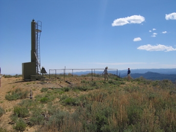
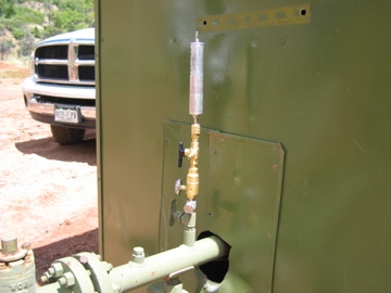
Cheyenne, WY: Casper aquifer east of Laramie Range: We drilled 1 and instrumented 7 Casper Aquifer wells in Belvoir Ranch. Water level
and temperature data are sent via telemetry.
[Drilling LTM No.1] [HydroVu]. To further understand partitioning between streams, riparian groundwater, and bedrock
groundwater at the mountain front, we've instrumented 6 stream sites along Lone Tree
Creek, Goose Creek, and Duck Creek that recharge the Casper Aquifer at the Ranch.
At each stream site, we've drilled 2 riparian wells. Thus, stream, riparian, and bedrock
groundwater levels are simutaneoulsly monitored.
[Video1]. [Video2]. [Well summary].
Carbon Sequestration
Wyoming is one of the leading energy-producing states in the country with the highest
per-capita CO 2 emission. Carbon sequestration and enhanced oil recovery (EOR) have been proposed
at many geological storage sites in the state's sedimentary basins. Our objective
is to understand and reduce model uncertainty in simulating CO 2 flow in geological formations characterized by sparse field and laboratory data. By
integrating parameter upscaling and uncertainty analysis, we aim to (1) identify the
most influential factor(s) that control CO 2 storage and leakage; (2) evaluate conceptual model uncertainty in developing heterogeneous
site models; (3) develop computationally efficient analytical proxy models to replace
reservoir simulation; (4) conduct history matching to enhance model's predictive capability.
Our long-term goal is to provide guidance to reduce the predictive uncertainty in
modeling field-scale sequestrations in an efficient and cost-effective manner. Below
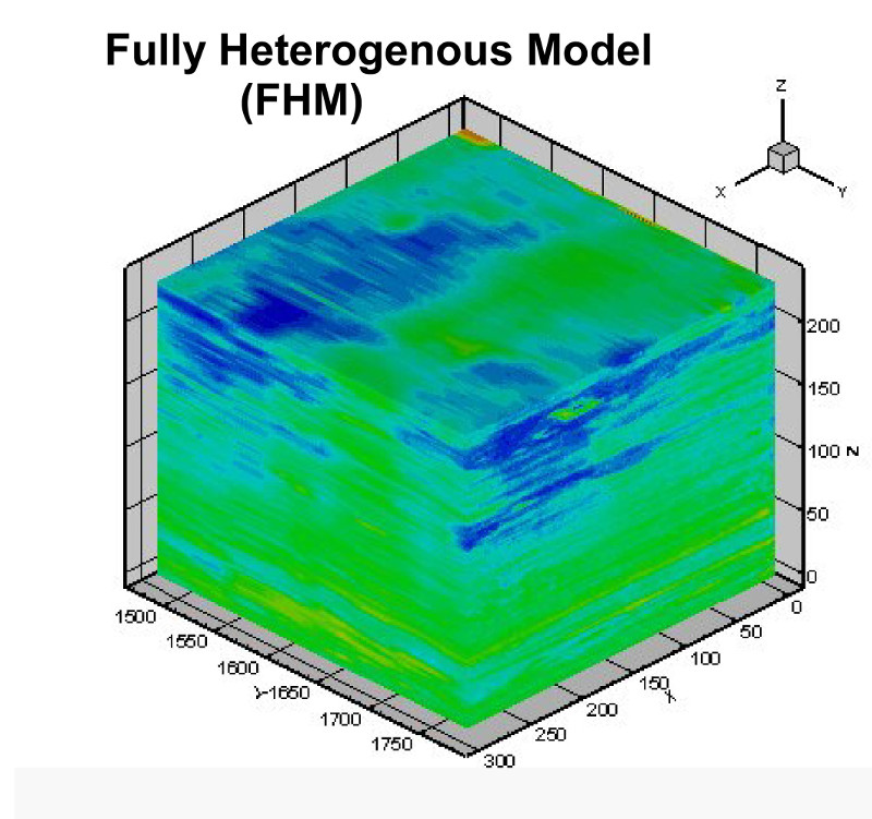
is CO 2 simulation result in synthetic systems within a sedimentary hierarchy, showing the
total gas-phase saturation (mobile + trapped) evolution over time (NSF EAR-0838250
and PRF 48773-DNI 8).
| Fully Heterogenous Model |
Facies Model |
Assemblage Model |
Formation Model |
 |
 |
 |
 |
| |
|
|
Wellbore: red (injection phase); grey (post-injection) |
A regional reservoir model in western Wyoming with significant dipping structure.
This site is proposed for acid gas disposal from an oil industry's gas plant. We have
extended the upscaling analysis to irregular (corner point) grids with significant
dips.
Regional Hydrogeology & Petroleum Geology
Sedimentary basins are host to important natural resources (oil, gas, water). In the
arid west, increasing attention focuses on the availability of freshwater and how
to protect this limited resource. In the Rocky Mountain region, a significant problem
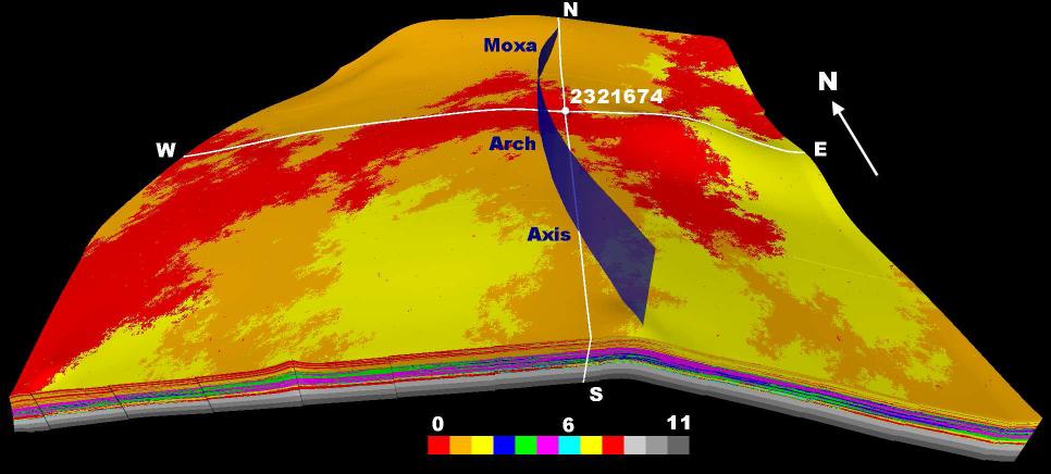
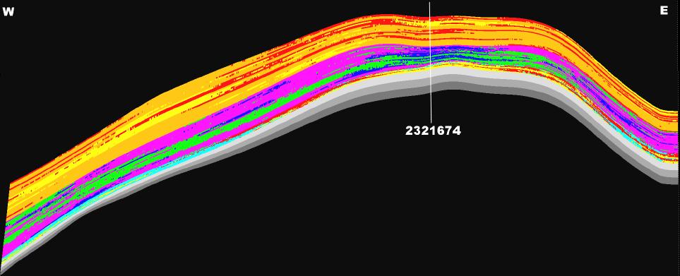
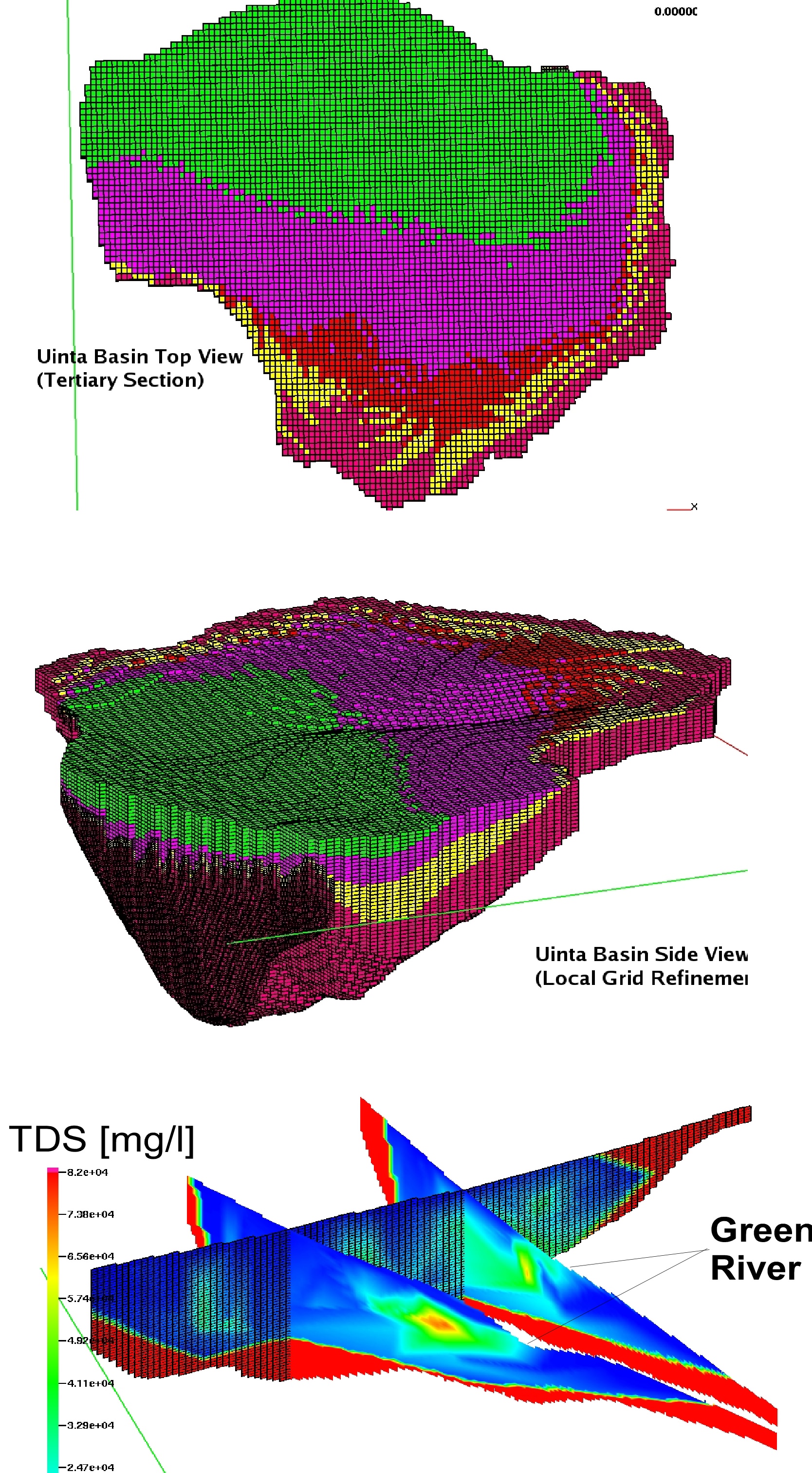
is the salinization of rivers and groundwaters. Where does the salt come from? A 3D
basin-scale model was built for the Uinta Basin in Utah, onto which existing water
chemistry (~860 USGS TDS data) is projected (below the third plot). Regional scale
upconing of saline water from 1~3 km depth is observed beneath the Green River. The
research objective is to understand the driving forces (e.g., natural recharge, mineral
dissolution, hydrocarbon production) behind such regional saline fluid migration and
to predict the salt fluxes to surface waters using a combination of modeling and field
measurements. Future work: (1) shale gas development on regional hydrology and salinization;
(2) the impact of climate change on the plumbing and salinization of the intermountane
basins.
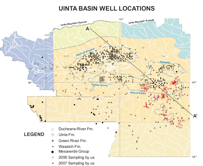
In the Rocky Mountain region, the development of tight gas reservoirs from sedimentary
basins is accelerating. However, both the nature, extent, and flow characteristics
of these gas deposits are poorly understood. A second project will use combined water/gas
geochemistry and numerical modeling to study the distribution, connectedness and subsurface
heterogeneity of tight-gas reservoirs. The second plot (seen below) shows the location
of gas wells we've sampled with perforation depth ranging from 4700 to 15000 ft. Along
with ~300 gas data provided by energy companies, gas composition can be plotted and
its migration studied at the regional scale.
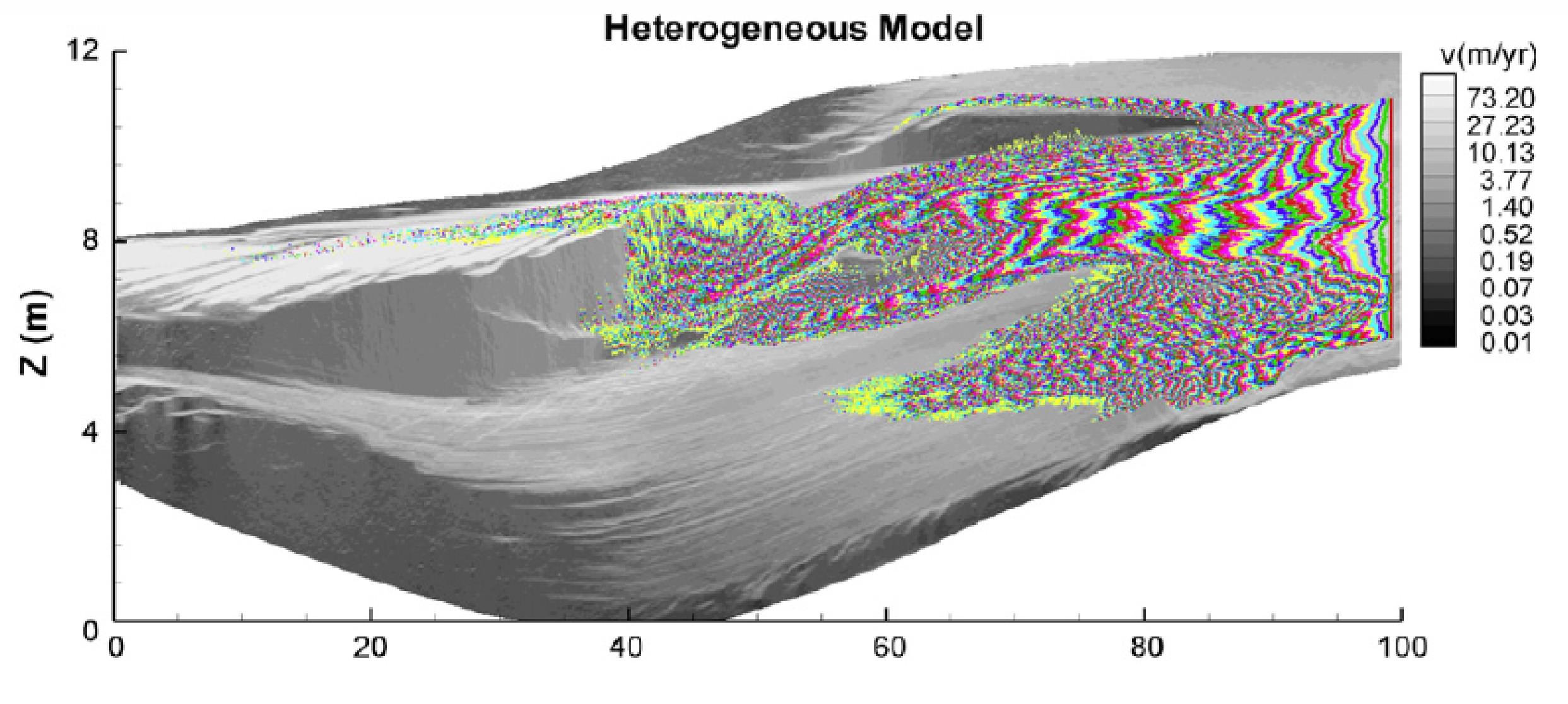
Heterogeneity & Effective Properties
Uncertainties in modeling subsurface fluid flow and solute transport can be significantly
reduced if the hydraulic conductivity (or permeability) heterogeneity is fully resolved.
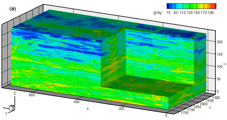
A set of deposits created in the Experimental EarthScape Facility, San Anthony Falls Hydraulic Lab, University of Minnesota, provides a unique opportunity
to understand the impact of heterogeneity on flow/transport, and the impact of using
effective parameters (effective conductivity, macrodispersivity) to represent the
"missing" or unresolved heterogeneity on model predictions (see Zhang et al., 2005,
2006, 2007, 2008 for details). Based on the stratigraphic data, new research will
explore the impact of three-dimensional heterogeneity on flow/transport (see below;
a cutaway reveals the internal sedimentary structure which controls permeability heterogeneity).
Changes in the prediction envelope and model sensitivity due to effective parameterizations
in the upscaled models is assessed via the Design of Experiment (Milliken et al.,
2007).
RWPT (Local Dispersivity = Hydrodynamic Dispersivity):
Transport modeling result (left) has been upscaled to a model with 14 hydrofacies
zones. Details can be found in a 2008 publication.
Experimental stratigraphy has graced the front cover of a new book "Effective Groundwater
Model Calibration" (Hill & Tiedeman, 2007), 455 pp., Wiley-Interscience. Book Website
Three-dimensional reconstructions of the deposit are created as virtual laboratories
for testing a variety of scaling and uncertainty analysis methodologies. Virtual Lab
A current project aims to understand the equivalent hydraulic conductivity (or permeability)
at multiple scales, using geological mapping, percolation analysis, and numerical
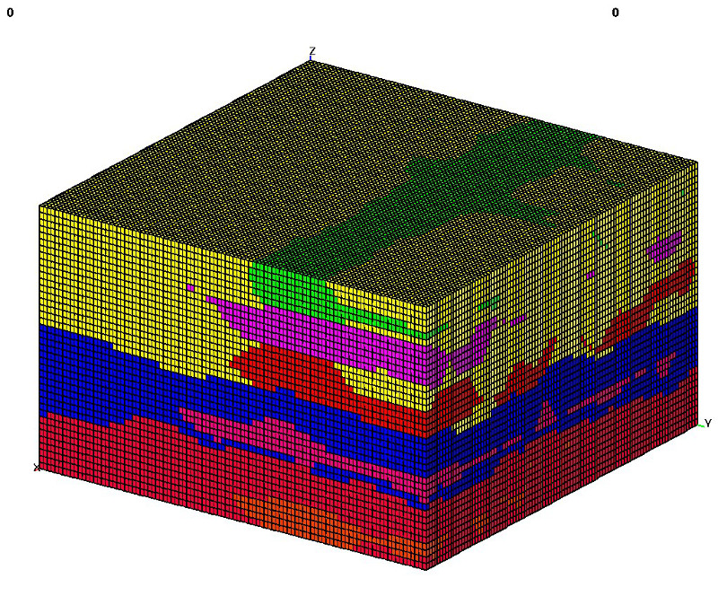
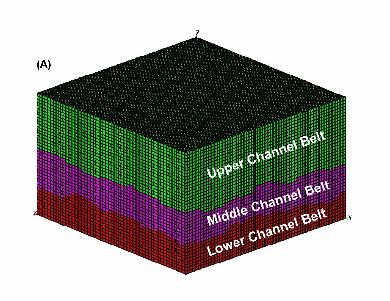
upscaling (see JPEG). Starting with a heterogeneous aquifer (upper left), we can model the aquifer
with (A), a formation-scale model, or (B), a facies-scale model ( model (B) is hierarchical to model (A); (C) is the top 3 channel facies of (B) ). Or, we can model the aquifer with significant high-K connectivity, based on results
of a percolation cluster analysis (bottom row). Equivalent conductivity upscaled for
various geological units or domains can be compared to inverse modeling estimates
of optimized conductivities. The issue of model complexity (i.e., finding an optimal
geological characterization level which is linked to the cost of a modeling study)
can further be studied.
Parallel Computing
Parallel computing has entered many science and engineering fields where large-scale
problems can no longer be solved efficiently with serial computers/algorithms. To
improve code efficiency, I've written parallel programs to solve for both flow and
transport by calling the MPI and other libraries, e.g., AZTEC. Large problems can
be solved within a fraction of the serial time. Below are results from small test
cases. Left: Steady-state single-phase incompressible flow, solved with serial and
parallel FE codes (mesh partition is done by Metis); Middle: Random walk particle
tracking. Recently, a 3D fully heterogenous flow equation is solved by a FD code calling
both MPI and PETSc (Right). See timing results and velocity fields. In the future,
I will explore alternative and more efficient approaches, e.g., DA object which divides
the domain into blocks (xs,xe,ys,ye,zs,ze) rather than nnode/np, and, parallel multigrid
solver.