
Grasshoppers of Wyoming and the West
Entomology
Ecological Factor Maps
Elevation
from Chapter III of Spatial Analysis of Ecological Factors Related to Grasshopper Population Dynamics in Wyoming
Vegetation Map | Precipitation Map | Elevation Map | Evapotranspiration Map | Soil Map
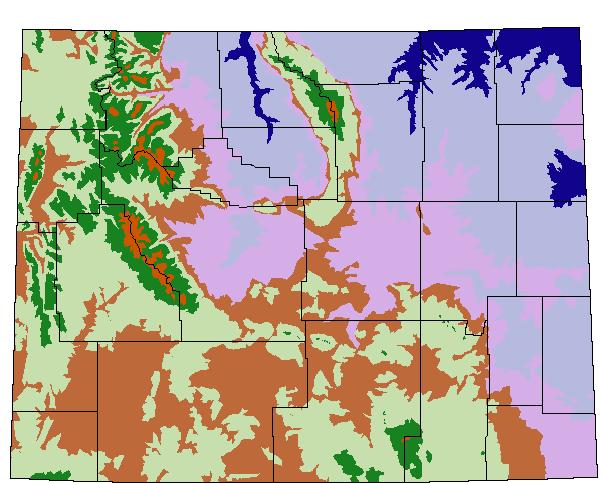
Fig. 4. Elevation map of Wyoming adapted from Martner (1986). Dark blue = <1200 m;
light blue = 1200-1500 m; violet = 1500-1800 m; brown = 1800-2100 m; green shading
= 2100-2700 m; green = 2700-3350 m; orange = >3350 m; black = state and county borders.
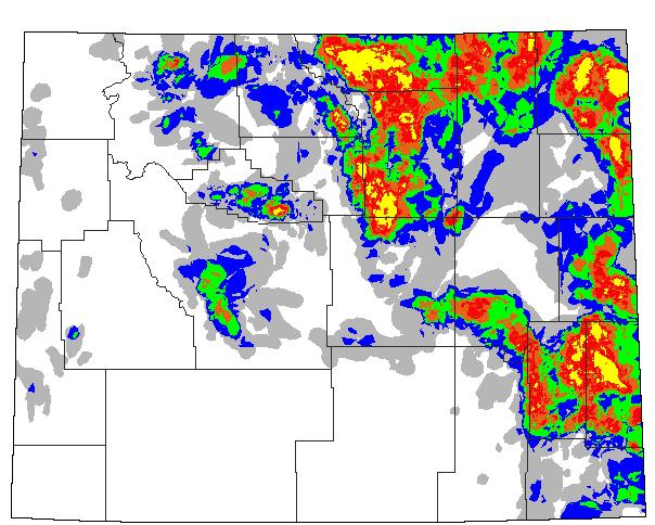
Fig. 1 (Updated from the 1960-93 map) Spatial distribution of rangeland grasshopper
outbreaks in Wyoming from 1944 to 1994, with no data for 1982, 1983 or 1984 (Schell
1994). White = no recorded infestations; light shading = 1-2 yr infested; dark shading
= 3-4 yr infested; purple = 5 yr infested; blue-green = 6-7 yr infested; red = 8-9
yr infested; orange =10-11 yr infested; yellow = 12-21 yr infested; black = state
and county borders.
The University of Wyoming has earned its Research Level 1 (R1) status from the Carnegie Classification of Institutions of Higher Education, placing Wyoming's only four-year university with the top research universities in the United States.