A Leader in Mapping Migrations
October 10, 2022

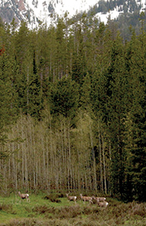
These mule deer on summer range in the Hoback Basin make one of the longest-distance
migrations ever documented, some 150 miles across the Green River Basin. (Photo courtesy
of Gregory Nickerson, Wyoming Migration Initiative)
The Wyoming Migration Initiative informs smart decisions for managing the West’s ungulates.
By Micaela Myers
Each fall and spring, we hear the honk of geese and other sounds of migratory birds. We look up at the choreographed flock and take in the beauty of nature calling. Other migrations, however, are not so easy for the animals. The American West is home to several species of migrating ungulates, including mule deer, bighorn sheep, bison, pronghorn, moose, elk, white-tailed deer and mountain goats. While birds also face habitat loss, they can fly right over the barriers ungulates must navigate between winter and summer ranges: fencing, roads and development. These issues pose major threats to the health of big game herds, but there are solutions — thanks in large part to work being done right here at the University of Wyoming.
Puzzle Pieces
Lucky for the ungulates, many folks — from hunters to conservationists — have long been interested in keeping herds healthy and addressing migration barriers. But at first, advances in migration science were not well integrated into on-the-ground conservation efforts or land management. Enter the Wyoming Migration Initiative (WMI), which is based at UW and now in its 10th year.
“The big epiphany that led to WMI was that there was all this science being done at UW and all this interest in corridors, but the science and research weren’t informing where the conservation work was being done,” says Lead Scientist Matthew Kauffman of the U.S. Geological Survey (USGS) Wyoming Cooperative Fish and Wildlife Research Unit in the Department of Zoology and Physiology.
Through GPS collaring of animals and developing software to map migration routes, WMI and partners were able to inform the conservation efforts and facilitate solutions to migration barriers, such as roadway overpasses and underpasses, wildlife-friendly fencing and easements on private working lands. WMI focuses on research, outreach and conservation tools — getting the information to the folks who make decisions and fund solutions.
“Wyoming has done cutting-edge research on migrations that’s known nationally and internationally,” Kauffman says. “Our state is home to some of the best-studied migrations. We’ve learned more than many other places on the planet. It’s emerging as
an area of research excellence.”

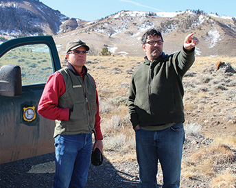
Cooperative mule deer migration mapping has helped to guide conservation on the eastern
edge of the Greater Yellowstone Ecosystem. In this photo UW researcher Matt Kauffman
(right) plans a mule deer capture operation with Wyoming Game and Fish biologist Bart
Kroger (left). (Photo courtesy of Gregory Nickerson, Wyoming Migration Initiative)
For example, in 2012 the team recorded the longest mule deer migration ever studied, where 1,000 mule deer migrate 10 to 150 miles from winter ranges in the Red Desert to summer ranges in the mountains of northwest Wyoming. That work led to a top 10 list of hazards for wildlife managers and conservationists to focus on.
“The top threat was the Fremont Lake bottleneck, where thousands of animals have to squeeze through a half-mile bottleneck between Pinedale and Fremont Lake,” Kauffman says. “The suburbs are encroaching. Right at the bottleneck, there was a 360-acre parcel of private land for sale and slated for subdivision to be made into lakeside cottages. With a migration map in hand, it became clear that that parcel was critically important for mule deer. The nonprofit Conservation Fund helped raise $2 million to purchase the land. They gave it to the Wyoming Game and Fish Department as a Wildlife Habitat Management Area. They removed the fences that were constraining the mule deer. That parcel is now protected forever for these migratory deer.”
On the outreach side, videos and traveling exhibitions help the public understand the work and the importance of migrations, garnering millions of views online. On social media, WMI provides a migration-tracking program, posting updates on one mule deer’s migration complete with photos from the deer’s tracking camera. In 2018, WMI and the University of Oregon InfoGraphics Lab published Wild Migrations: Atlas of Wyoming’s Ungulates, the first state-based book of its kind.
GPS collar studies involve many university, state and federal partners, including the Wyoming Game and Fish Department, the Monteith Shop in UW’s Haub School of Environment and Natural Resources (see page 18), Shoshone and Arapaho Fish and Game, and federal agencies such as the Bureau of Land Management and the National Park Service. “Together we’ve mapped a couple dozen migrations across Wyoming,” Kauffman says. “That data is being used to identify problematic roads and fences.”
Using those maps, conservation groups and state agencies have put tens of millions of dollars toward conserving migration corridors and seasonal ranges.
Finding Solutions
Everyone has a role to play in managing migrations through the public process. While WMI and the Wyoming Cooperative Fish and Wildlife Research Unit provide the maps and data analysis, nonprofits and government entities including the U.S. Forest Service, Wyoming Department of Transportation and Wyoming Game and Fish Department — working with private landowners — implement the solutions.
“In the Green River Basin, there are hundreds of miles of fences that have been retrofitted for wildlife and similar projects going on in other parts of the state,” says Associate Research Scientist Gregory Nickerson.

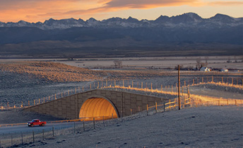
The Trappers Point wildlife overpass on U.S. Route 191 near Pinedale was completed
in 2012 by the Wyoming Department of Transportation as part of a larger project that
included six underpasses, two overpasses and several miles of wildlife exclusion fencing.
The efforts helped drastically reduce mule deer and pronghorn mortalities. (Photo
by Leon Schatz/Gregory Nickerson/WMI)
Overpasses and underpasses save not only ungulates but also drivers and the costs associated with accidents. “The major roadway crossing structures across the state have been led by the Wyoming Department of Transportation working with Wyoming Game and Fish, and to their credit, many of them were built before WMI came along,” Nickerson says. “New migration data is helping to accelerate such projects.”
Wyoming has become such a leader in studying migrations that Kauffman and the USGS corridor mapping team he leads were asked to work with other Western states.
“Now we’re exporting our approach to mapping — and using the maps to identify threats and conversation opportunities — to the rest of the western U.S.,” he says. Volume 1 of Ungulate Migrations of the Western United States was released in 2020, and volume 2 came out in April 2022. This successful partnership with Western states also involves tribal nations, such as the Eastern Shoshone and Northern Arapaho on the Wind River Indian Reservation.
“This atlas of ungulate migrations is an incredible resource for anyone who cares about the West’s big-game herds and the challenges they face,” says Whit Fosburgh, president and CEO of the Theodore Roosevelt Conservation Partnership. “The Theodore Roosevelt Conservation Partnership appreciates the commitment demonstrated by the Interior Department, USGS, and numerous Western states and tribes in delineating these crucial corridors.”
Zachary Lowe, executive director of the Western Association of Fish and Wildlife Agencies, adds: “The big-game corridor mapping program is strongly supported by Western fish and wildlife agencies and serves as a model of how empirical science facilitates collaborative landscape-level conservation efforts through state and federal cooperation. I am hard-pressed to think of many other successful landscape conservation efforts that have garnered such broad support from these diverse stakeholders so quickly.”
In the coming year, WMI and the USGS corridor mapping team will collaborate with Western wildlife agencies to complete volumes 3 and 4 of Ungulate Migrations of the Western United States and will work with local partners toward the goal of mapping the most significant ungulate migrations in Wyoming. Long term, WMI aims to keep advancing appreciation for Wyoming’s amazing migrations and providing the science needed to keep herds moving across the American West into the future.
